|
| Mesoscale Discussion 1422 |
|
< Previous MD Next MD >
|
|
Mesoscale Discussion 1422
NWS Storm Prediction Center Norman OK
0137 PM CDT Tue Jul 09 2019
Areas affected...Northeast Wyoming...Southwest South
Dakota...Northwest Nebraska
Concerning...Severe potential...Watch possible
Valid 091837Z - 092100Z
Probability of Watch Issuance...60 percent
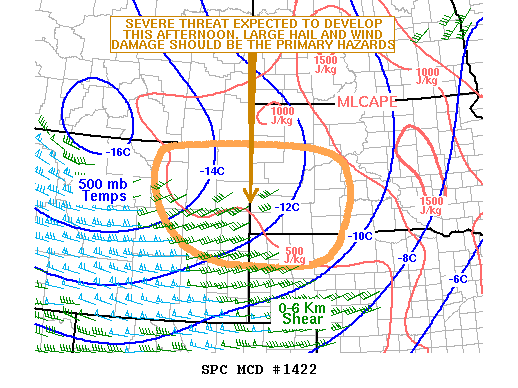
SUMMARY...A severe threat is expected to develop this afternoon
across parts of the northern High Plains. Wind damage and isolated
large hail will be possible with the stronger thunderstorms. Weather
watch issuance may be needed across the region.
DISCUSSION...The latest surface analysis shows a post-frontal
airmass over the northern High Plains with northwest low-level flow.
Surface dewpoints are generally in the 50s F from northeast Wyoming
into southwest South Dakota. Weak instability has develops across
the area over the last few hours with the RAP estimating MLCAPE
values in the 500 to 1000 J/kg range. This combined with large-scale
ascent associated with a shortwave trough over the northern Rockies
will provide support for continued convective development this
afternoon. In addition to increasing instability, the Rapid City
WSR-88D VWP shows 0-6 km shear around 40 kt. This combined with
steep mid-level lapse rates will be sufficient for a few severe
storms with isolated large hail potential. Damaging wind gusts will
also be possible especially if a line of storms can organize late
this afternoon.
..Broyles/Grams.. 07/09/2019
...Please see www.spc.noaa.gov for graphic product...
ATTN...WFO...ABR...LBF...UNR...CYS...BYZ...RIW...
LAT...LON 45020418 44920647 44660694 44060703 43290668 42630590
42330486 42260404 42240311 42320195 42730130 43740087
44170090 44660115 44940221 45020418
|
|
Top/All Mesoscale Discussions/Forecast Products/Home
|
|


 @NWSSPC