|
| Mesoscale Discussion 1148 |
|
< Previous MD Next MD >
|
|
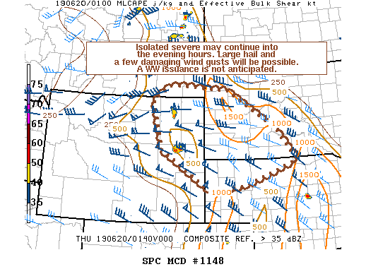
   Mesoscale Discussion 1148
   NWS Storm Prediction Center Norman OK
   0902 PM CDT Wed Jun 19 2019

   Areas affected...extreme southeast Montana...northeast
   Wyoming...western South Dakota...far northwest Nebraska

   Concerning...Severe potential...Watch unlikely

   Valid 200202Z - 200400Z

   Probability of Watch Issuance...20 percent

   SUMMARY...Isolated severe hail/wind gusts remain possible with the
   stronger storms into the evening. A WW issuance is not currently
   anticipated given the sparse, marginal nature of the severe threat.

   DISCUSSION...Multicellular clusters and transient supercells persist
   across the northern High Plains, where isolated instances of large
   hail and damaging wind gusts have been reported over the past few
   hours. With steep low and mid-level lapse rates in place, large hail
   (though isolated) will continue to remain a concern. Damaging wind
   gusts will also be possible given the relatively dry surface-700 mb
   air mass in place, which may promote efficient hydrometeor
   evaporation and associated cooling with the stronger downdrafts.

   As nocturnal cooling continues, boundary-layer stabilization will
   slowly increase, reducing the overall buoyancy and associated
   updraft intensity with time. Nonetheless, steep lapse rates atop a
   stable boundary layer may still foster marginally severe hail growth
   with storms that persist and become elevated, though the severe
   coverage would be very sparse by this point. Given the isolated
   extent of the severe threat, a WW issuance is not expected.

   ..Squitieri/Edwards.. 06/20/2019

   ...Please see www.spc.noaa.gov for graphic product...

   ATTN...WFO...ABR...LBF...UNR...CYS...BYZ...RIW...

   LAT...LON   42030379 43330589 44910627 45380552 45220301 43960092
               42920005 42170227 42030379
|
|
Top/All Mesoscale Discussions/Forecast Products/Home
|
|


 @NWSSPC