|
| Mesoscale Discussion 1121 |
|
< Previous MD Next MD >
|

|
   Mesoscale Discussion 1121
   NWS Storm Prediction Center Norman OK
   0332 PM CDT Tue Jun 18 2019

   Areas affected...North central Oklahoma

   Concerning...Severe potential...Watch possible

   Valid 182032Z - 182130Z

   CORRECTED FOR GRAPHIC

   Probability of Watch Issuance...40 percent

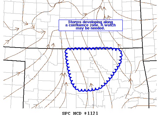
   SUMMARY...Storms are developing along a confluence zone in north
   central Oklahoma. A watch may be needed.

   DISCUSSION...An area of towering cumulus extends along the I-35
   corridor from the Kansas border to just north of Oklahoma City.
   Storms have started to develop in Grant and Garfield counties with
   signs in visible satellite imagery that additional storm development
   may occur farther south along the line. Do not expect any
   development south of I-40/I-44 given the weaker low-level confluence
   with southern extent.

   A modified 18Z LMN sounding shows MLCAPE around 1500 J/kg and
   effective shear around 25 knots. This would support some storm
   organization with a combination of multicell and isolated supercell
   storm mode.

   Areas north of the OK/KS border are covered by tornado watch 395,
   but a small severe thunderstorm watch may be needed to cover the
   severe threat from these storms.

   ..Bentley/Guyer.. 06/18/2019

   ...Please see www.spc.noaa.gov for graphic product...

   ATTN...WFO...TSA...OUN...

   LAT...LON   36979812 36989742 36999615 36919563 36489571 36099603
               35809631 35579666 35519723 35539763 35869786 36479803
               36979812
|
|
Top/All Mesoscale Discussions/Forecast Products/Home
|
|


