|
| Mesoscale Discussion 1079 |
|
< Previous MD Next MD >
|
|
Mesoscale Discussion 1079
NWS Storm Prediction Center Norman OK
0628 PM CDT Sat Jun 15 2019
Areas affected...south-central and southeast IN
Concerning...Tornado Watch 360...
Valid 152328Z - 160030Z
The severe weather threat for Tornado Watch 360 continues.
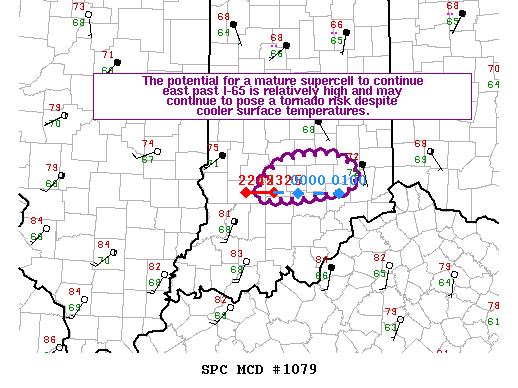
SUMMARY...The potential for a mature supercell to continue east past
I-65 is relatively high and may continue to pose a risk for
tornadoes despite cooler surface temperatures. If this occurs, a
small tornado watch to the east of tornado watch 360 will be
considered for parts of southeast IN and the IN/KY/OH tri-state area
to address this threat.
DISCUSSION...Visible satellite imagery shows a cumulus field beneath
broken high-level cloud cover over southeast IN. Surface
temperatures near the greater Louisville/Kentuckiana portion of the
OH River are in the lower 80s but cooler conditions are noted
farther northeast near Cincinnati (lower 70s). There is uncertainty
how far the supercell tornado risk will continue into southeast IN.
The primary supercell over Monroe County, IN provides the greatest
probability for this to occur. Convective/mesoscale trends will be
monitored over the next 1-2 hours as the south-central IN activity
moves to the east edge of tornado 360.
..Smith.. 06/15/2019
...Please see www.spc.noaa.gov for graphic product...
ATTN...WFO...ILN...IND...
LAT...LON 39398644 39438556 39088540 38968677 39398644
|
|
Top/All Mesoscale Discussions/Forecast Products/Home
|
|


 @NWSSPC