|
| Mesoscale Discussion 589 |
|
< Previous MD Next MD >
|
|
Mesoscale Discussion 0589
NWS Storm Prediction Center Norman OK
0207 PM CDT Wed May 08 2019
Areas affected...Far East Texas...Western Louisiana and Far
Southwest Arkansas
Concerning...Severe potential...Watch likely
Valid 081907Z - 082000Z
CORRECTED FOR GRAPHIC TEXT LABEL
Probability of Watch Issuance...95 percent
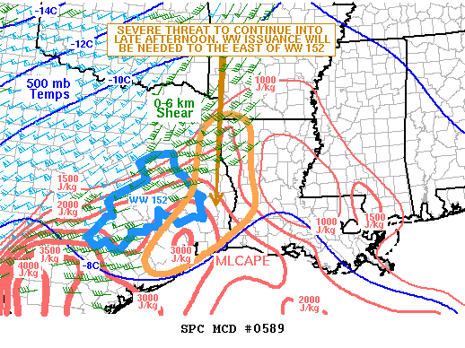
SUMMARY...A severe threat is expected to develop across far east
Texas and western Louisiana late this afternoon. Tornadoes, wind
damage and hail will be possible. Weather watch issuance will likely
be needed soon.
DISCUSSION...The latest radar imagery shows a linear MCS extending
from northeast Texas southwestward into south-central Texas. A moist
airmass with surface dewpoints in the lower 70s F is located ahead
of the MCS across the Texas Coastal Plains and Sabine River Valley.
The RAP is estimating MLCAPE values across the moist sector in the
2000 to 3000 J/kg range. In addition, the Houston, Lake Charles and
Fort Polk WSR-88D VWPs have moderate deep-layer shear. The low-level
shear on these VWPs are also enhanced with 0-3 km storm relative
helicity generally in the 300 to 400 m2/s2 range. This will be
favorable for tornadoes associated with rotating cells embedded in
the line. Wind damage will also be likely with bowing segments as
well.
..Broyles/Guyer.. 05/08/2019
...Please see www.spc.noaa.gov for graphic product...
ATTN...WFO...LCH...SHV...HGX...
LAT...LON 33069426 32679463 31829477 31109491 29999583 29379618
29029587 29139523 29669428 30079368 30579311 31009296
31649307 32829314 33159366 33069426
|
|
Top/All Mesoscale Discussions/Forecast Products/Home
|
|


 @NWSSPC