|
| Mesoscale Discussion 401 |
|
< Previous MD Next MD >
|
|
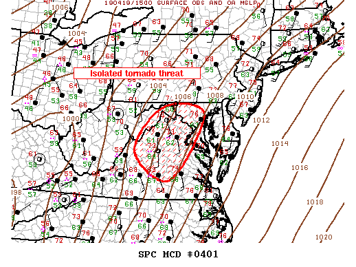
   Mesoscale Discussion 0401
   NWS Storm Prediction Center Norman OK
   1108 AM CDT Fri Apr 19 2019

   Areas affected...Middle Atlantic

   Concerning...Severe potential...Watch likely

   Valid 191608Z - 191815Z

   Probability of Watch Issuance...80 percent

   SUMMARY...Severe threat is expected to gradually increase across the
   Middle Atlantic region into the mid-afternoon hours.

   DISCUSSION...LLJ is gradually increasing across the Middle Atlantic
   region in response to strong upstream short-wave trough. Scattered
   convection has been noted along the nose of this jet as it
   translates into VA. Several long-lived rotating updrafts, with and
   without lightning, are evolving within this warm advection zone.
   Current thinking is supercell threat will gradually increase across
   central VA as surface dew points rise into the mid 60s. This
   activity will spread toward MD as the afternoon progresses. Tornado
   threat will be higher with these pre-squall line supercells, while
   wind damage should be more common with a forced squall line later
   this afternoon.

   ..Darrow/Thompson.. 04/19/2019

   ...Please see www.spc.noaa.gov for graphic product...

   ATTN...WFO...AKQ...LWX...RNK...

   LAT...LON   38137943 39567825 39337654 37177799 38137943
|
|
Top/All Mesoscale Discussions/Forecast Products/Home
|
|


 @NWSSPC