|
| Mesoscale Discussion 390 |
|
< Previous MD Next MD >
|
|
Mesoscale Discussion 0390
NWS Storm Prediction Center Norman OK
0312 PM CDT Thu Apr 18 2019
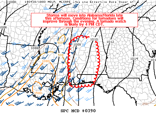
Areas affected...Portions of western/central Alabama...Western
Florida Panhandle
Concerning...Severe potential...Tornado Watch likely
Valid 182012Z - 182215Z
Probability of Watch Issuance...95 percent
SUMMARY...Storms will move into the discussion area late this
afternoon and early evening. Observational and numerical model
trends both suggest and increase in the potential for damaging winds
and tornadoes. A tornado watch will likely be issued by 4 PM CDT.
DISCUSSION...Afternoon boundary-layer mixing has reduced dewpoints
across the discussion area by 1-3 F. Still, modifying the 18Z BMX
sounding with surface observations across the region suggests that
capping is eroding across southern Alabama and vicinity with
destabilization perhaps a few more hours away in central Alabama.
Latest surface analysis shows a deepening area of surface pressure
in Louisiana into western Mississippi. With the continued approach
of an upper-level trough, continued deepening of the surface low is
anticipated through the overnight period. This mass response will
increase theta-e advection into the western Florida Panhandle and
Alabama helping to boost MLCAPE values 500-1500 J/kg by early
evening.
Observational trends in KDGX and KLIX VAD profiles have shown a
large increase in low level hodograph curvature and SRH. These
trends should continue as the trough shifts eastward. Guidance has
suggested a marked increase in the low-level jet across much of
Alabama during the 7-11 PM CDT time period. Given these expected
favorable low-level shear parameters along with effective deep-layer
shear of around 60 kts, organized convection with mid and low-level
rotation appears likely. A tornado watch will be needed for this
area. Aside from the tornado threat, strong winds fields will
support a threat for damaging wind gusts as well.
..Wendt/Grams.. 04/18/2019
...Please see www.spc.noaa.gov for graphic product...
ATTN...WFO...TAE...BMX...MOB...
LAT...LON 33458820 33858751 33728641 33438590 31778575 30788608
30278627 30168771 30188816 31658831 32638831 33458820
|
|
Top/All Mesoscale Discussions/Forecast Products/Home
|
|


 @NWSSPC