|
| Mesoscale Discussion 380 |
|
< Previous MD Next MD >
|
|
Mesoscale Discussion 0380
NWS Storm Prediction Center Norman OK
1107 PM CDT Wed Apr 17 2019
Areas affected...far southeast KS into southwest MO
Concerning...Severe potential...Watch likely
Valid 180407Z - 180530Z
Probability of Watch Issuance...80 percent
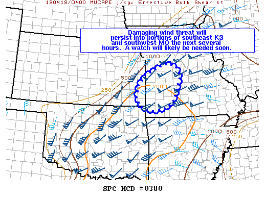
SUMMARY...Damaging winds will be possible with storms tracking into
southeast KS and southwest MO over the next several hours. A severe
thunderstorm watch will likely be needed soon.
DISCUSSION...An intense bow echo moving into northeast OK as of 04z
is tracking toward the east/northeast at around 40-45 kt. The bow
has produced widespread severe wind gusts near 55-70 mph over the
last couple of hours. VWPs from INX and SGF show favorable vertical
wind profiles for maintaining strong to severe organized convection
and a moist and moderately unstable downstream airmass persists well
into southwest MO. A rear inflow jet appears to well established
with the bow echo as well based on radar trends over the last 1-2
hours. It appears likely that damaging winds associated with this
bow echo should persist northeastward into southeast KS and adjacent
parts of southwest MO.
Additional severe thunderstorms capable of damaging winds are also
ongoing along a cold front from east-central KS into northeast MO
just south of the Kansas City metro area. With these two areas of
concern expected to persist the next several hours, a new watch is
expected soon across the MCD area.
..Leitman/Hart.. 04/18/2019
...Please see www.spc.noaa.gov for graphic product...
ATTN...WFO...LSX...SGF...EAX...TSA...ICT...
LAT...LON 37919499 38369458 38729392 38899336 38759290 38319265
37709286 37239306 36919353 36789405 36879454 37009486
37339510 37919499
|
|
Top/All Mesoscale Discussions/Forecast Products/Home
|
|


 @NWSSPC