|
| Mesoscale Discussion 378 |
|
< Previous MD Next MD >
|
|
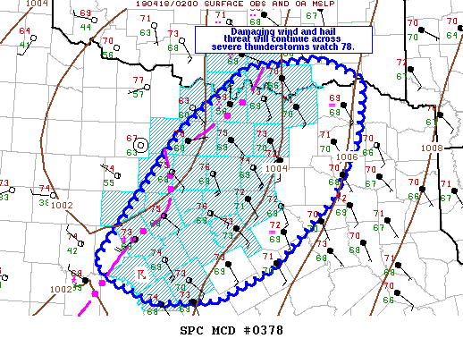
   Mesoscale Discussion 0378
   NWS Storm Prediction Center Norman OK
   0930 PM CDT Wed Apr 17 2019

   Areas affected...portions of north Texas and far south-central OK

   Concerning...Severe Thunderstorm Watch 78...

   Valid 180230Z - 180400Z

   The severe weather threat for Severe Thunderstorm Watch 78
   continues.

   SUMMARY...Damaging winds will be the primary threat with storms
   tracking east/northeast across north Texas this evening, though some
   hail potential will continue in the short term, especially near the
   Red River.

   DISCUSSION...Two areas of intense storms are currently tracking
   east/northeast across WW 78. The northern area of storms near the
   Red River have continued to produce large hail from 1 to 1.75 inches
   and strong wind gusts this evening. Guidance suggests these storms
   will continue to track along the Red River the next several hours.
   Strong instability some increase in 850-700 mb flow is possible
   based on observations from the VWP at FWS and SRX. Based on this,
   severe potential may extend outside the current watch boundary by
   around 04z as suggested by current track forecast.

   Further south, another strong to severe line of storms from Erath to
   Brown Counties in central TX also will continue moving into an
   environment supportive of severe storms, similar to that further to
   the north. Radar trends have not been as robust with respect to hail
   production, which is not unexpected given linear storm mode.
   Damaging winds will continue to be the threat with this line of
   convection toward midnight. As with storms near the Red River, the
   forecast track currently brings storms to the edge of WW 78 by
   around 04-05Z, and either an aerial extension or new watch may need
   to be considered if intensity trends continue.

   ..Leitman.. 04/18/2019

   ...Please see www.spc.noaa.gov for graphic product...

   ATTN...WFO...SHV...TSA...FWD...OUN...SJT...

   LAT...LON   33299793 34099696 34219578 33939517 33189526 32439568
               31599654 31179738 31149829 31399887 31619916 33299793
|
|
Top/All Mesoscale Discussions/Forecast Products/Home
|
|


 @NWSSPC