|
| Mesoscale Discussion 354 |
|
< Previous MD Next MD >
|
|
Mesoscale Discussion 0354
NWS Storm Prediction Center Norman OK
0642 PM CDT Sun Apr 14 2019
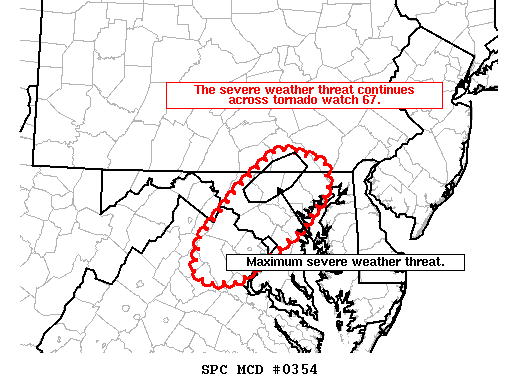
Areas affected...far northern Virginia...central Maryland...and far
southeast Pennsylvania
Concerning...Tornado Watch 67...
Valid 142342Z - 150045Z
The severe weather threat for Tornado Watch 67 continues.
SUMMARY...The severe weather threat continues across tornado watch
67.
DISCUSSION...A few low-topped supercells continue to rotate in
central Maryland. These storms will likely be responsible for the
primary severe weather threat in tornado watch 67 for the next hour
or two. Given the low-topped nature of the storms and very little
lightning, the hail threat will continue to be minimal with a
primary threat of damaging winds and an isolated tornado. It is
uncertain how long this threat will continue, as most guidance
suggests this activity will wane within the next hour or two.
However, the environment ahead of these storms is not expected to
change much within the next few hours and it seems possible that the
threat from these initial storms may persist beyond 01Z.
..Bentley.. 04/14/2019
...Please see www.spc.noaa.gov for graphic product...
ATTN...WFO...PHI...CTP...LWX...
LAT...LON 38977801 39557745 39997690 39847619 39507615 39047659
38487746 38477791 38607808 38977801
|
|
Top/All Mesoscale Discussions/Forecast Products/Home
|
|


 @NWSSPC