|
| Mesoscale Discussion 352 |
|
< Previous MD Next MD >
|
|
Mesoscale Discussion 0352
NWS Storm Prediction Center Norman OK
0612 PM CDT Sun Apr 14 2019
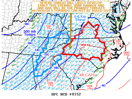
Areas affected...Northeast Georgia...Western South
Carolina...Western and Central North Carolina...Far Eastern
Tennessee...Southwestern Virginia...Far Southern West Virginia
Concerning...Severe Thunderstorm Watch 62...66...
Valid 142312Z - 150115Z
The severe weather threat for Severe Thunderstorm Watch 62, 66
continues.
SUMMARY...A severe threat appears likely to continue across parts of
the southern and central Appalachian Mountains. Wind damage and hail
will be the primary threats but a tornado can not be ruled out.
Weather watch issuance will probably be needed across the region at
the expiration of WW 62.
DISCUSSION...The latest surface analysis shows a cold front from
eastern Kentucky extending south-southwestward into north-central
Georgia. Scattered thunderstorms are ongoing along and just ahead of
the front. A moist airmass is present to the east of the front and
the RAP is showing an axis of instability from northeastern Georgia
into western North Carolina, where MLCAPE values are estimated to be
in the 1000 to 1500 J/kg range. In addition, the Knoxville, TN
WSR-88D VWP shows 65 to 70 kt of 0-6 km shear suggesting the
environment will continue to support severe storms early this
evening. Supercells and organized multicells will have potential for
wind damage and isolated large hail. Although the tornado threat
appears to have decreased some across the region, a brief tornado or
two can not be ruled out, especially with cells that rotate.
..Broyles/Guyer.. 04/14/2019
...Please see www.spc.noaa.gov for graphic product...
ATTN...WFO...RAH...RNK...RLX...CAE...GSP...MRX...FFC...
LAT...LON 36778228 37518171 37768120 37468001 36967931 36457929
35367992 34238117 33738186 33558283 33618327 33858374
34418385 35088344 35678312 36778228
|
|
Top/All Mesoscale Discussions/Forecast Products/Home
|
|


 @NWSSPC