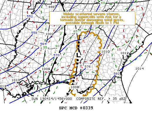
   Mesoscale Discussion 0339
   NWS Storm Prediction Center Norman OK
   1007 AM CDT Sun Apr 14 2019

   Areas affected...Parts of the Florida Panhandle...much of western
   Georgia and adjacent portions of eastern Alabama

   Concerning...Tornado Watch 59...60...

   Valid 141507Z - 141630Z

   The severe weather threat for Tornado Watch 59, 60 continues.

   SUMMARY...Widely scattered strong to severe storms will overspread
   the region through midday, particularly across areas south through
   southeast of the Atlanta metro area, accompanied by the risk for
   damaging wind gusts and a couple of tornadoes.

   DISCUSSION...Considerable remnant stratiform precipitation is
   impeding/slowing boundary layer destabilization, but scattered
   vigorous thunderstorm development persists along a pre-frontal
   surface trough associated with overnight convection.  This is
   advancing eastward across the Georgia/Alabama border vicinity and
   western Florida Panhandle, roughly along the western edge of a 40-50
   kt southerly 850 mb jet axis.

   Despite the lack of stronger insolation, seasonably high boundary
   layer moisture content, including mid/upper 60s across the piedmont
   to near 70 across much of the rest of Georgia/Florida, may still
   contribute to gradually increasing CAPE up to around 1000 J/kg
   through early afternoon.  And, although low-level hodographs may not
   be exhibiting substantial clockwise turning with height, shear
   beneath the low-level jet may still be sufficient for the evolution
   of low-level mesocyclones with an associated risk for tornadoes
   and/or locally strong surface gusts.

   Convection will gradually spread across western into central
   Georgia, and toward the Florida Big Bend region, through 16-17Z,
   with perhaps the most prominent storms now spreading north-northeast
   of Columbus GA into areas near/south and east of the Atlanta metro
   area, associated with a weak area of low pressure.

   ..Kerr.. 04/14/2019

   ...Please see www.spc.noaa.gov for graphic product...

   ATTN...WFO...FFC...TAE...BMX...

   LAT...LON   30178586 32218532 33848519 34258451 33728334 32548351
               30378394 29668462 29388531 30178586
|


 @NWSSPC