|
| Mesoscale Discussion 281 |
|
< Previous MD Next MD >
|
|
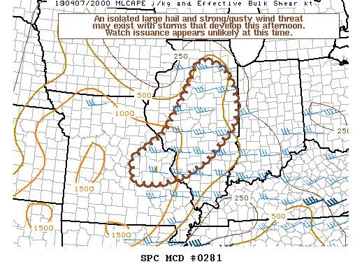
   Mesoscale Discussion 0281
   NWS Storm Prediction Center Norman OK
   0314 PM CDT Sun Apr 07 2019

   Areas affected...Portions of east-central MO into central/northern
   IL

   Concerning...Severe potential...Watch unlikely

   Valid 072014Z - 072245Z

   Probability of Watch Issuance...20 percent

   SUMMARY...An isolated large hail and strong/gusty wind threat may
   exist with thunderstorms that develop this afternoon. Watch issuance
   appears unlikely at this time due to the overall marginal
   environment.

   DISCUSSION...Isolated to perhaps widely scattered thunderstorms
   should develop within the next hour or so along a surface trough
   from east-central MO into central/northern IL as large-scale ascent
   preceding a shortwave trough overspreads this region. Immediately
   ahead of the surface trough temperatures have generally warmed into
   the upper 60s to lower 80s, with dewpoints mostly in the mid 50s to
   lower 60s. Resultant weak instability, with MLCAPE in the 250-1000
   J/kg range, and effective bulk shear of 30-40 kt may be sufficient
   for some updraft organization. Isolated large hail may be the
   primary threat as cool mid-level temperatures and modestly steepened
   mid-level lapse rates associated with the shortwave trough move
   across this region. Strong/gusty downdraft winds could also occur,
   particularly where low-level lapse rates have been steepened through
   diurnal heating. Overall storm coverage and the limited
   thermodynamic environment suggest the severe threat will probably
   remain marginal/isolated, and watch issuance appears unlikely at
   this time.

   ..Gleason/Hart.. 04/07/2019

   ...Please see www.spc.noaa.gov for graphic product...

   ATTN...WFO...LOT...ILX...LSX...DVN...SGF...

   LAT...LON   38579192 39519056 40788975 41428942 41858910 41598816
               40918774 40108761 39628786 38588893 38108984 37859081
               37889185 38579192
|
|
Top/All Mesoscale Discussions/Forecast Products/Home
|
|


 @NWSSPC