|
| Mesoscale Discussion 191 |
|
< Previous MD Next MD >
|
|
Mesoscale Discussion 0191
NWS Storm Prediction Center Norman OK
0459 AM CDT Wed Mar 13 2019
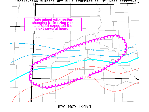
Areas affected...portions of far northwest NE into central SD
Concerning...Winter mixed precipitation
Valid 130959Z - 131400Z
SUMMARY...A narrow corridor of rain changing to and/or mixing with
freezing rain and sleet is expected for a few hours this morning.
DISCUSSION...Surface temperature observations from far northwest NE
into southwest and south-central SD are running a few degrees warmer
compared forecast guidance as of 09z. This is resulting in mainly
rain with the band of precipitation lifting northward into southern
SD currently. However, as the surface low over eastern CO continues
to intensify early this morning, colder air over northern SD will
shift southward with time as northeasterly low level flow
strengthens. As such, a narrow corridor of rain should mix with
frozen precip types before transitioning to freezing rain and sleet
further north over the next couple of hours. This freezing rain and
sleet should persist for a few hours this morning before a
stronger/deeper cold surge works southward and a transition to all
snow occurs later this afternoon.
..Leitman.. 03/13/2019
...Please see www.spc.noaa.gov for graphic product...
ATTN...WFO...FSD...ABR...LBF...UNR...CYS...
LAT...LON 43530395 44170208 44480074 44649989 44659939 44569916
44339895 44079898 43789934 43330042 42870219 42670338
42860404 43090413 43530395
|
|
Top/All Mesoscale Discussions/Forecast Products/Home
|
|


 @NWSSPC