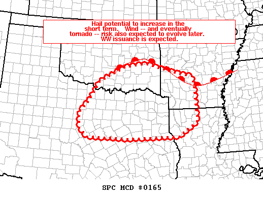
   Mesoscale Discussion 0165
   NWS Storm Prediction Center Norman OK
   0303 AM CST Sat Mar 09 2019

   Areas affected...portions of north Texas and adjacent southeast
   Oklahoma across the Arklatex

   Concerning...Severe potential...Watch likely

   Valid 090903Z - 091100Z

   Probability of Watch Issuance...80 percent

   SUMMARY...Risk for large hail -- eventually evolving to include
   potential for damaging winds and a tornado or two -- is expected to
   increase over the next few hours.  WW issuance is expected.

   DISCUSSION...Latest radar imagery shows an increase in convective
   intensity east of the ABI/DYS area at this time, at the leading edge
   of increasing large-scale ascent ahead of the advancing/potent upper
   system.

   Downstream of the convective increase, the airmass remains slightly
   stable at low levels despite 60s dewpoints, but with steep lapse
   rates above 850 mb.  As ascent continues to overspread this area, a
   increase in convective coverage/intensity is expected near and ahead
   of the Pacific front.  Convective mode remains somewhat uncertain,
   though at this time it appears that a loose band of storms will
   evolve near the boundary initially, with some increase in potential
   for pre-frontal/more isolated storms to occur later this morning
   into the Arklatex region.  In any case, deep-layer shear already
   supports mid-level rotation, with increasing flow aloft ahead of the
   advancing upper system enhancing the favorability of the kinematic
   environment with time.

   At this time, it appears that severe risk will remain primarily in
   the form of hail in the short term.  However, even slight
   destabilization of the boundary layer would support increasing
   potential for surface-based convection, and an associated/
   corresponding increase of risk for damaging winds and a tornado or
   two.  While this low-level destabilization would seem most likely to
   evolve after sunrise -- when some weak heating could contribute,
   enough destabilization due to moisture transport alone could support
   an increase in surface-based severe risk prior to sunrise --
   especially over eastern portions of the discussion area.

   ..Goss/Edwards.. 03/09/2019

   ...Please see www.spc.noaa.gov for graphic product...

   ATTN...WFO...LZK...SHV...TSA...FWD...OUN...

   LAT...LON   31789828 32159872 32839875 33479822 34239773 34899640
               35049528 34609352 34429271 32459259 31829357 31729621
               31789828
|


 @NWSSPC