Mesoscale Discussion 0146
NWS Storm Prediction Center Norman OK
0120 PM CST Sun Mar 03 2019
Areas affected...Far northeast Louisiana...south-central into
southeast Mississippi...southern into central Alabama...far western
Florida Panhandle
Concerning...Tornado Watch 7...
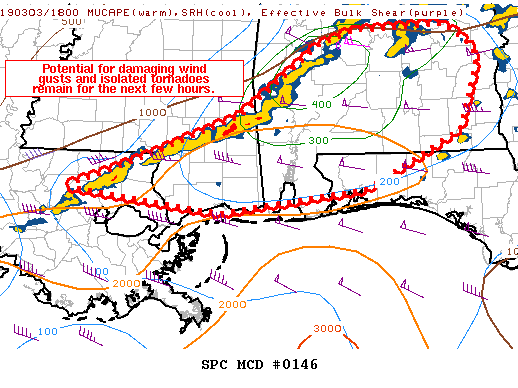
Valid 031920Z - 032115Z
The severe weather threat for Tornado Watch 7 continues.
SUMMARY...Risk for damaging wind gusts and isolated tornadoes
continues with the squall line across the MS/AL border.
DISCUSSION...Convection has recently organized into a linear
complex, now located roughly along a line from west of Selma, AL to
Lake Pontchartrain. As a surface low, now located over central
Alabama, continues to track eastwards, the associated squall line
will continue to progress east into a moist, modestly unstable
airmass (with up to 1000 J/kg MLCAPE noted, especially across
southern Alabama).
Transient supercell structures have recently been noted within the
line, with a TDS noted in Washington County, AL around 1850Z. 1848Z
MOB VAD profiler data suggests 0-1km SRH over 250 m2/s2, with 400
m2/s2 0-3km SRH in association with an isallobarically driven
low-level jet, suggesting tornado potential will continue across
this area for the next few hours. In addition, a few damaging wind
gusts will also be possible with forward- and rear-flank downdrafts
in transient supercell structures, as well as with any bowing
segments within the line.
..Squitieri.. 03/03/2019
...Please see www.spc.noaa.gov for graphic product...
ATTN...WFO...TAE...BMX...MOB...JAN...LIX...
LAT...LON 30589097 30899011 31458864 32278756 32448708 32508582
32228544 32058537 31268565 30598694 30338891 30589097
|


 @NWSSPC