|
| Mesoscale Discussion 66 |
|
< Previous MD Next MD >
|

|
   Mesoscale Discussion 0066
   NWS Storm Prediction Center Norman OK
   0151 AM CST Mon Feb 04 2019

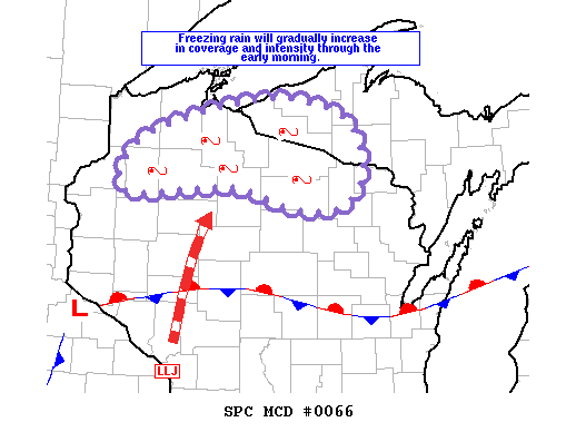
   Areas affected...northern Wisconsin through western Upper Michigan

   Concerning...Freezing rain

   Valid 040751Z - 041245Z

   SUMMARY...Freezing rain is expected to gradually increase in
   coverage and intensity through the early morning, initially across
   northern WI, but expanding into western portions of lower MI after
   11Z. Rates occasionally from .05 to locally exceeding .1 inch per
   hour are possible.

   DISCUSSION...Early this morning a quasi-stationary front extends
   from a very weak surface low in southeast MN eastward through
   central WI. North of this boundary surface temperatures are below
   freezing, ranging from around 32F to 27F. WV imagery shows a
   progressive shortwave trough over the Northern Plains, and this
   feature will contribute to slight deepening of the surface low and
   modest strengthening of a southerly low level jet across WI as it
   continues eastward. As a result, warm advection and isentropic
   ascent will gradually increase within baroclinic zone across
   northern WI. These processes will contribute to development of a
   melting layer and a shallow, weak unstable layer above the surface.
   Scattered showers over central WI will spread northward, and
   precipitation should gradually become more widespread over northern
   WI within the zone of increasing isentropic ascent. Temperatures in
   the melting layer will warm such that the dominant precipitation
   type should become freezing rain with rates at times up to .1 inch
   per hour in heavier convective elements.

   ..Dial/Grams.. 02/04/2019

   ...Please see www.spc.noaa.gov for graphic product...

   ATTN...WFO...MQT...GRB...DLH...

   LAT...LON   46199186 46519097 46688982 46498884 46058856 45628875
               45558947 45789047 45719200 46199186
|
|
Top/All Mesoscale Discussions/Forecast Products/Home
|
|


