|
| Mesoscale Discussion 1688 |
|
< Previous MD Next MD >
|

|
   MESOSCALE DISCUSSION 1688
   NWS STORM PREDICTION CENTER NORMAN OK
   0206 PM CDT FRI JUL 22 2011

   AREAS AFFECTED...ERN MT

   CONCERNING...SEVERE POTENTIAL...WATCH NEEDED SOON

   VALID 221906Z - 221930Z

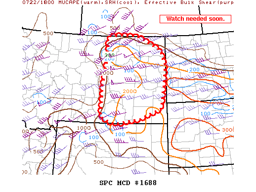
   SURFACE BASED STORMS HAVE DEVELOPED AND A WW WILL BE ISSUED SOON
   FOR PORTIONS OF ERN MT.

   STORMS ARE DEVELOPING WEST OF GGW AS LARGE SCALE FORCING SPREADS IN
   FROM THE WEST. DEEP LAYER SHEAR AROUND 50 KT AND MUCAPE VALUES FROM
   1000 TO 2000 J/KG WILL BE FAVORABLE WITH SUPERCELLS.THE MAIN THREAT
   WITH INITIAL STORMS WILL BE VERY LARGE HAIL...THOUGH STRONGLY
   VEERING HODOGRAPHS INDICATE A TORNADO OR TWO IS CERTAINLY POSSIBLE.
   LATER THIS AFTERNOON...THE STORMS ARE LIKELY TO MERGE INTO A FAST
   EWD MOVING LINEAR SYSTEM.

   ..IMY.. 07/22/2011


   ATTN...WFO...BYZ...GGW...

   LAT...LON   45210578 44980743 45270831 46790826 48190795 48960799
               49020712 49010597 48360440 47610407 46640423 45680443
               45210578
|
|
Top/All Mesoscale Discussions/Forecast Products/Home
|
|


