|
| Mesoscale Discussion 1444 |
|
< Previous MD Next MD >
|
|
MESOSCALE DISCUSSION 1444
NWS STORM PREDICTION CENTER NORMAN OK
0343 PM CDT WED JUN 29 2011
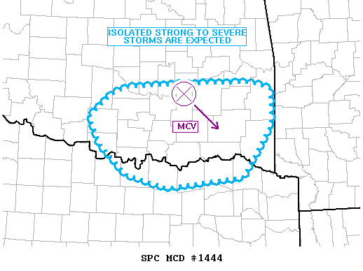
AREAS AFFECTED...SERN OK...NERN TX
CONCERNING...SEVERE POTENTIAL...WATCH UNLIKELY
VALID 292043Z - 292245Z
SUBSTANTIAL INSTABILITY IS IN PLACE WITH LITTLE CIN OVERALL AS
TEMPERATURES CONTINUE TO WARM. VISIBLE IMAGERY SHOWS THE REMNANTS OF
AN MCV DRIFTING SEWD ACROSS SERN OK WITH ASSOCIATED MID LEVEL
CONVECTION. IMAGERY ALSO SHOWS BOUNDARY LAYER CU BEGINNING TO EXPAND
ALONG THE I-35 CORRIDOR AS WELL AS OVER FAR ERN OK WHERE DEWPOINTS
REMAIN IN THE 68-70 F RANGE.
WEAK SURFACE CONVERGENCE...CONTINUED HEATING...AND THE MCV MAY
RESULT IN SUFFICIENT MESOSCALE FOCI FOR ISOLATED STORMS. WITH WEAK
WINDS ALOFT...ACTIVITY WOULD LIKELY PULSE WITH DOWNBURST
POTENTIAL...POSSIBLY CONTAINING HAIL GIVEN STEEP POTENTIAL FOR VERY
STRONG UPDRAFTS.
..JEWELL.. 06/29/2011
ATTN...WFO...SHV...TSA...FWD...OUN...
LAT...LON 35019455 34449454 33609509 33429659 33649738 34159792
34569810 34909770 35039742 35119630 35119491 35019455
|
|
Top/All Mesoscale Discussions/Forecast Products/Home
|
|


 @NWSSPC