|
| Mesoscale Discussion 1330 |
|
< Previous MD Next MD >
|
|
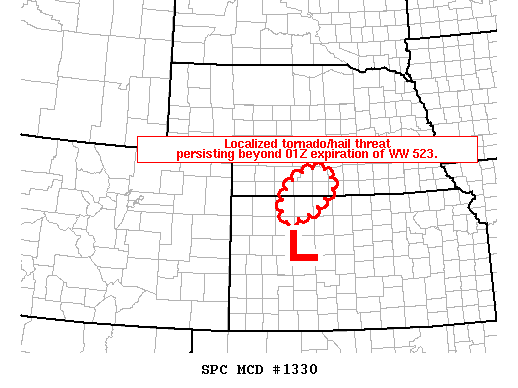
   MESOSCALE DISCUSSION 1330
   NWS STORM PREDICTION CENTER NORMAN OK
   0721 PM CDT MON JUN 20 2011

   AREAS AFFECTED...SWRN/S-CNTRL NEB...NWRN/N-CNTRL KS

   CONCERNING...TORNADO WATCH 523...

   VALID 210021Z - 210045Z

   THE SEVERE WEATHER THREAT FOR TORNADO WATCH 523 CONTINUES.

   WITH A TORNADO/SEVERE HAIL THREAT LIKELY PERSISTING BEYOND 01Z
   SCHEDULED EXPIRATION OF WW 523...A REPLACEMENT WW OR LOCAL TEMPORAL
   EXTENSION WILL BE COORDINATED SHORTLY.

   STRONG TO SEVERE TSTMS PERSIST ALONG THE NWRN KS/SWRN NEB BORDER
   WITHIN THE NRN PIVOT POINT OF MID-LEVEL VORT MAX IN W-CNTRL KS. AS
   THIS VORT CENTER SHIFTS EWD AND WITH THE ONSET OF NOCTURNAL
   COOLING...SEVERE THREAT SHOULD GRADUALLY DIMINISH THIS EVENING.
   HOWEVER...A LOCALIZED AREA OF SEVERE POTENTIAL MAY CONTINUE THROUGH
   ABOUT 03-04Z.

   ..GRAMS.. 06/21/2011


   ATTN...WFO...GID...LBF...GLD...

   LAT...LON   39430039 39800062 40340029 40619985 40649937 40589919
               40389906 40149904 39779945 39569981 39430039
|
|
Top/All Mesoscale Discussions/Forecast Products/Home
|
|


 @NWSSPC