|
| Mesoscale Discussion 1264 |
|
< Previous MD Next MD >
|
|
MESOSCALE DISCUSSION 1264
NWS STORM PREDICTION CENTER NORMAN OK
0339 PM CDT FRI JUN 17 2011
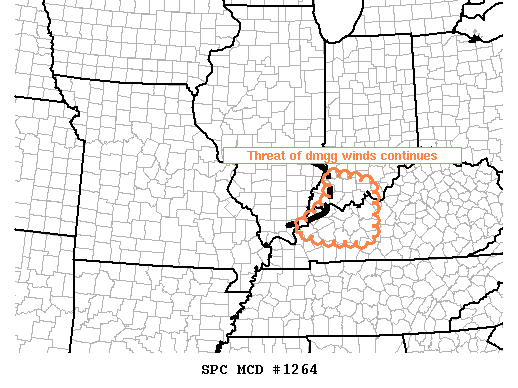
AREAS AFFECTED...SRN IL...SWRN IND...WRN KY
CONCERNING...SEVERE THUNDERSTORM WATCH 491...
VALID 172039Z - 172145Z
THE SEVERE WEATHER THREAT FOR SEVERE THUNDERSTORM WATCH 491
CONTINUES.
THREAT OF DMGG WINDS WILL CONTINUE TO PROGRESS ESEWD THROUGH THE WW
AREA. STABLE AREAS IN THE WAKE OF THE BOWING SEGMENT MAY BE CLEARED
FROM THE WATCH.
AMPLE SURFACE HEATING ALLOWED SUFFICIENT SURFACE-BASED
DESTABILIZATION TO OCCUR DOWNSTREAM OF A BOWING SEGMENT THAT IS
MOVING INTO SWRN IND/FAR WRN KY AS OF 2030Z. EXTRAPOLATION PLACES
THE SRN /STRONGEST PORTION/ OF THE BOW AT THE ERN EDGE OF THE WW BY
22-23Z. HOWEVER...RADAR VELOCITIES SUGGEST WINDS HAVE GENERALLY
BECOME SUBSEVERE. SHOULD THIS TREND CONTINUE...A NEW WW MAY BE
UNNECESSARY EAST OF THE CURRENT WW OVER CNTRL KY.
..HURLBUT.. 06/17/2011
ATTN...WFO...LMK...IND...PAH...
LAT...LON 38638751 38408618 37048627 37148777 37388848 37758791
38148745 38638751
|
|
Top/All Mesoscale Discussions/Forecast Products/Home
|
|


 @NWSSPC