|
| Mesoscale Discussion 853 |
|
< Previous MD Next MD >
|
|
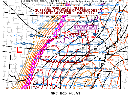
   MESOSCALE DISCUSSION 0853
   NWS STORM PREDICTION CENTER NORMAN OK
   0106 PM CDT SUN MAY 22 2011

   AREAS AFFECTED...ERN KS...NERN OK...MUCH OF SRN AND SWRN MO...NRN AR

   CONCERNING...SEVERE POTENTIAL...TORNADO WATCH LIKELY

   VALID 221806Z - 222000Z

   A TORNADO WATCH WILL BE ISSUED SHORTLY.

   AN EXTREMELY UNSTABLE AIR MASS HAS DEVELOPED E OF THE DRYLINE WITH
   DEWPOINTS NEAR 70 F BENEATH STEEP MID LEVEL LAPSE RATES. NEARLY ALL
   CONVECTIVE INHIBITION HAS BEEN ERODED...THUS EXPECTED CU ALONG THE
   DRYLINE TO ERUPT INTO INTENSE SUPERCELLS. EXTREMELY LARGE HAIL IS
   LIKELY...AND ALTHOUGH LOW LEVEL SHEAR IS A BIT MARGINAL...IT WILL BE
   MORE THAN SUFFICIENT FOR TORNADOES GIVEN EXTREME INSTABILITY.

   ..JEWELL.. 05/22/2011


   ATTN...WFO...LSX...LZK...SGF...EAX...TSA...ICT...

   LAT...LON   36619153 36159187 36009275 36049408 36049519 36099643
               36459673 36859655 37749573 38249409 38389294 38389201
               37969159 37169139 36619153
|
|
Top/All Mesoscale Discussions/Forecast Products/Home
|
|


 @NWSSPC