(All days are valid from 12 UTC - 12 UTC the following day)
Note: A severe weather area depicted in the Day 4-8 period indicates 15%, 30% or higher probability for severe thunderstorms within 25 miles of any point.
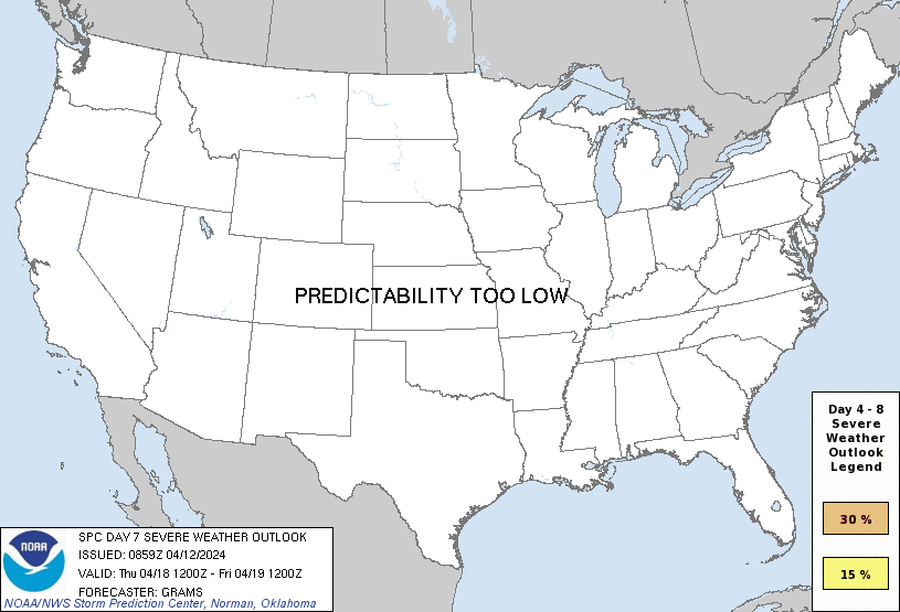
PREDICTABILITY TOO LOW is used to indicate severe storms may be possible based on some model scenarios. However, the location or occurrence of severe storms are in doubt due to: 1) large differences in the deterministic model solutions, 2) large spread in the ensemble guidance, and/or 3) minimal run-to-run continuity.
POTENTIAL TOO LOW means the threat for a regional area of organized severe storms appears unlikely (i.e., less than 15%) for the forecast day.
Forecast Discussion
ZCZC SPCSWOD48 ALL
ACUS48 KWNS 120859
SPC AC 120859
Day 4-8 Convective Outlook
NWS Storm Prediction Center Norman OK
0359 AM CDT Fri Apr 12 2024
Valid 151200Z - 201200Z
...DISCUSSION...
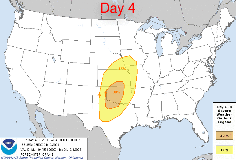
...Significant severe weather possible late afternoon Monday through
Tuesday evening across the central states...
Latest ensemble and deterministic guidance continues an overall
slower trend with the evolution of an amplifying shortwave trough
expected to be over parts of the Southwest early Monday. As it
crosses the southern Rockies into the central Great Plains by midday
Tuesday, the tropospheric flow field will amplify Monday night
through Tuesday morning. Substantial lee cyclogenesis will occur
over the central High Plains by Monday afternoon, and this cyclone
should track into the Mid-MO Valley vicinity by Tuesday afternoon
before occluding over the Upper MS Valley late Tuesday. This overall
slower trend results in expansion of severe probabilities
west-southwestward on D5.
Low-level moisture modification from the northwest Gulf, while
sufficient for severe storms, does not appear to be overly rich. As
such, the more westward initiation of convection during the late
afternoon to early evening Monday may be within a more deeply mixed
environment across parts of the dryline. Still, there is consensus
that a plume of low to mid 60s surface dew points should be advected
ahead of the dryline across much of western OK into western north
TX. More widespread convective development will occur during the
evening to overnight time frame, especially as the Pacific cold
front overtakes the dryline and surges east from parts of KS
southward. With this coinciding with the period of tropospheric flow
amplification, it is plausible an extensive convective band is
maintained east-northeast into early Tuesday. Whether this outpaces
the relatively confined warm-moist sector and weakens, or is
maintained through the end of D4 is unclear. This will have profound
implications on the degree of daytime destabilization downstream
over parts of the Corn Belt to the south-central states. With slower
timing, and if convection can adequately weaken, a conditionally
more favorable tornado threat may occur on Tuesday over the Mid-MS
Valley vicinity. Otherwise, should convection continue
east-northeast, greater buoyancy may largely be confined south
across the Ark-La-Tex into the Mid-South. As such, will defer to
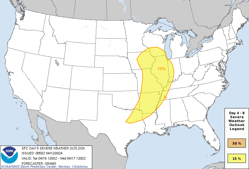
later outlooks for a potential 30 percent area on D5-Tuesday.
Severe probabilities appear too low in D6-8 to warrant consideration
of highlights as predictability wanes.
..Grams.. 04/12/2024
CLICK TO GET WUUS48 PTSD48 PRODUCT


 @NWSSPC