Day 4-8 Severe Weather Outlook Issued on Apr 10, 2024
Updated: Wed Apr 10 09:01:03 UTC 2024
Day 4 Risk
Area (sq. mi.)
Area Pop.
Some Larger Population Centers in Risk Area
No Risk Areas Forecast
Day 5 Risk
Area (sq. mi.)
Area Pop.
Some Larger Population Centers in Risk Area
No Risk Areas Forecast
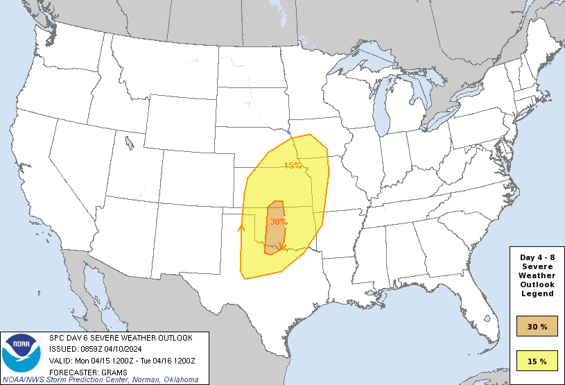
Day 6 Risk
Area (sq. mi.)
Area Pop.
Some Larger Population Centers in Risk Area
30 %
23,217
1,752,554
Oklahoma City, OK...Norman, OK...Wichita Falls, TX...Lawton, OK...Edmond, OK...
15 %
227,473
15,070,360
Fort Worth, TX...Kansas City, MO...Omaha, NE...Tulsa, OK...Arlington, TX...
Day 7 Risk
Area (sq. mi.)
Area Pop.
Some Larger Population Centers in Risk Area
No Risk Areas Forecast
Day 8 Risk
Area (sq. mi.)
Area Pop.
Some Larger Population Centers in Risk Area
No Risk Areas Forecast
D4
Sat, Apr 13, 2024 - Sun, Apr 14, 2024
D7
Tue, Apr 16, 2024 - Wed, Apr 17, 2024
D5
Sun, Apr 14, 2024 - Mon, Apr 15, 2024
D8
Wed, Apr 17, 2024 - Thu, Apr 18, 2024
D6
Mon, Apr 15, 2024 - Tue, Apr 16, 2024
(All days are valid from 12 UTC - 12 UTC the following day)
Note: A severe weather area depicted in the Day 4-8 period indicates 15%, 30% or higher probability for severe thunderstorms within 25 miles of any point.
PREDICTABILITY TOO LOW is used to indicate severe storms may be possible based on some model scenarios. However, the location or occurrence of severe storms are in doubt due to: 1) large differences in the deterministic model solutions, 2) large spread in the ensemble guidance, and/or 3) minimal run-to-run continuity.
POTENTIAL TOO LOW means the threat for a regional area of organized severe storms appears unlikely (i.e., less than 15%) for the forecast day.
Forecast Discussion
   ZCZC SPCSWOD48 ALL
   ACUS48 KWNS 100859
   SPC AC 100859

   Day 4-8 Convective Outlook
   NWS Storm Prediction Center Norman OK
   0359 AM CDT Wed Apr 10 2024

   Valid 131200Z - 181200Z

   ...DISCUSSION...
   Primary feature of concern will be an amplified upper low that is
   initially off the CA coast at 12Z Saturday. This low should dampen
   as it steadily progresses across the Southwest, before amplifying
   once again as it emerges onto the central Great Plains sometime on
   D6, as a separate shortwave trough digs towards the Pacific
   Northwest. Timing spread within the 00Z deterministic and ensemble
   guidance appears larger relative to yesterday, with the 00Z ECMWF
   decidedly trending farther east over the past 24 hours. It appears
   to be on the eastern envelope compared to its ensemble members. The
   overall forecast impact is with regard to dryline placement and
   surface cyclone evolution during the day on Monday and beyond.

   The actual severe weather setup appears substantial. Air mass
   modification will ensue northward from the western Gulf on D3, with
   multiple days to improve the low-level moisture profile amid well
   above-normal surface temperatures and a pronounced elevated mixed
   layer. With the likely flow field amplification through the
   troposphere, all ingredients appear present for a significant severe
   weather day on D6/Monday. The areal uncertainty of the synoptic
   features is the primary limiting factor. For now, have added a
   confined 30 percent highlight to indicate the higher-end potential
   and the most probable corridor, while broadening the previous 15
   percent area.

   A lesser severe threat will probably continue into D7/Tuesday. But
   even further spatial uncertainty, in conjunction with the impact of
   the prior day convection and consensus signal for the deep cyclone
   to occlude northeastward, renders low confidence for highlighting a
   severe threat area yet. The area-of-interest appears to have shifted
   more to the east relative to yesterday, in an arc around the eastern
   Corn Belt to the Ark-La-Tex.

   ..Grams.. 04/10/2024

   CLICK TO GET WUUS48 PTSD48 PRODUCT


 @NWSSPC