August 9-10, 2000 DERECHOS
"The Appalachian-crossing Derechos of August 9-10, 2000"
Thunderstorms made weather history over
parts of West Virginia and neighboring states on August 9-10, 2000 in that not one but two separate derecho-producing
convective systems crossed the central and southern Appalachian Mountains within a twelve-hour period. While one
or two derechos typically occur each year over the Ohio Valley (see Derecho climatology),
for various reasons derecho frequency significantly decreases over and east of the Appalachians. In this case, two
back-to-back "progressive"-type derechos crossed the Appalachian Mountains of West Virginia, Virginia, North Carolina, and northern
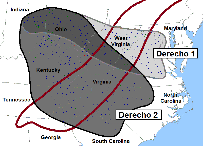
South Carolina, causing one death, at least 15 injuries, and several million dollars worth of damage (Figure 1).
Most of the damage was, however, restricted to downed trees and power lines. The second derecho was particularly unusual in that
it persisted throughout the night, producing locally damaging winds in the South Carolina piedmont beyond sunrise on
Thursday, August 10. Severe nocturnal storms are quite rare over the southeastern states in summer, especially
over mountainous terrain.
|
|
Figure 1. Top: Approximate paths (gray and black contours) and storm reports (wind, blue squares; hail, green squares; tornadoes, red squares) associated with the two derecho-producing convective systems of August 9-10, 2000 over the east-central United States. Area affected by Derecho 1 shown in light gray, area affected by Derecho 2 in medium gray, and area affected by both in dark gray. Red contour denotes general location of the Appalachian Mountains. Bottom: Outline of the attendant 40 dBZ radar contours at three-hour intervals (EDT), with Derecho 1 shaded light gray and Derecho 2 medium gray.
Derecho 1 --- Morning through early evening, Indiana to Virginia
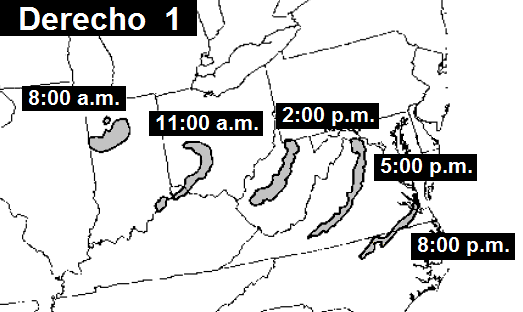
Figure 2. Severe weather associated with Derecho 1 during the twelve-hour period from 7:00 a.m. EDT (1100 UTC) to 7:00 p.m. EDT (2300 UTC) Wednesday, August 9. Counties shaded reported at least one instance of wind damage and/or at least one severe wind gust (50 kts or 58 mph, estimated or measured) during the time range (EDT) indicated. Hail reports depicted by triangles, and tornadoes by funnel icons. (Base map courtesy of S. Keighton, S. Nogueira, and N. Belk, NOAA-NWS).
Derecho 1 (Figure 2) formed in an environment that was more or less typical of those associated with summertime "progressive-type" derechos
in the Ohio Valley (see Types of Derechos and
Derechos and Heat Waves). For several days prior to Wednesday, August 9, stronger-than-normal westerly flow had prevailed across
the northern United States, from the northern plains and upper Mississippi Valley into New England. This belt of enhanced jet stream
flow marked the northern fringe of an elongated area of high pressure that extended from the central Rockies to the south Atlantic coast
(Figure 3). Warm and very humid air was present at the surface south of the jet; dewpoints (an absolute measure of atmospheric moisture)
averaged in the mid-70s (°F) throughout a broad swath extending from the mid-Mississippi Valley to the mid and south Atlantic coast.
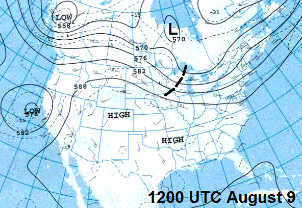
On the morning of the August 9th, a seasonably strong jet stream disturbance, with wind speeds in excess of 60 kts (69 mph), was over
Minnesota and Wisconsin (Figure 3, left panel). This disturbance was associated with an eastward-moving cold front over the mid-Mississippi valley.
Scattered thunderstorms formed along and ahead of the front over eastern Iowa and western Illinois during the pre-dawn hours of 9th in response to
strengthening ascent and low-level moisture return ahead of the jet impulse. The combination of rich moisture and relatively fast,
unidirectional west-northwesterly mid-tropospheric flow south of the jet enabled the storms to evolve into a small, arc-shaped line --- a
bow echo --- as they approached the Illinois-Indiana border soon after sunrise (Figures 4 and 5).
|
|
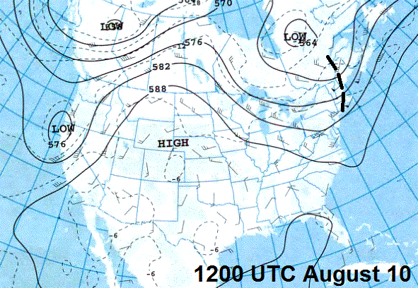
Figure 3. 500 mb (approximately 18,000 foot) upper air analyses for part of North America valid 8:00 a.m. EDT (1200 UTC) August 9 (left) and August 10 (right), 2000. Black lines are contours of the 500 mb pressure surface, labeled in decameters (e.g., "576" = 5,760 meters or 18,900 feet). Wind flow is parallel to the contours and depicted at radiosonde observation sites in the form of "barbs" and "flags;" full barb = 10 kts (1.15 mph); flag = 50 kts (58 mph). Thin dashed lines are isotherms (°C; e.g., -10 = minus 10 °C). Heavy dashed lines over the upper Mississippi Valley on August 9 and over New England on August 10 mark axis of the upper-level disturbance or "jet streak" mentioned in the text.
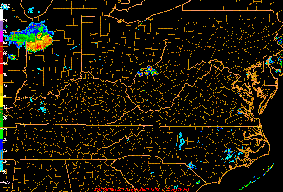
Figure 4. Nineteen-hour composite radar base reflectivity loop showing development and evolution of the August 9-10, 2000 derecho-producing convective systems. Animation begins at 8:00 a.m. EDT (1200 UTC) Wednesday, August 9 and ends at 2:55 a.m. EDT (0655 UTC) Thursday, August 10. Loop pauses at 9:30 p.m. August 9 (0130 UTC August 10) to show formation of a line echo wave pattern ("LEWP") over southern West Virginia. Reflectivity intensity scale at left (dBZ). (Base data courtesy of S. Keighton, WFO Blacksburg, Virginia).
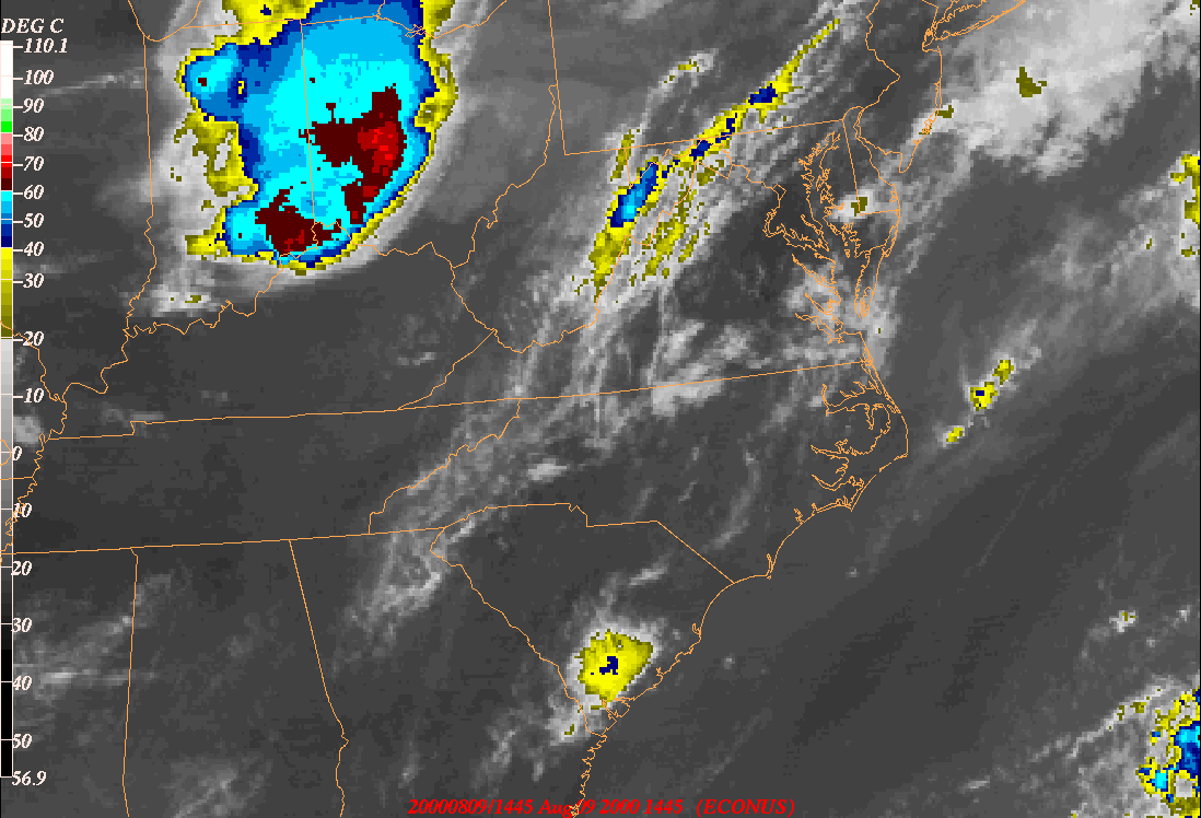
Figure 5. Twenty-one-hour infrared data satellite loop showing the development and evolution of the two derecho-producing mesoscale convective systems of August 9-10, 2000. "Ping-pong" animation begins at 10:45 a.m. EDT (1445 UTC) August 9 and ends at 7:45 a.m. EDT (1145 UTC) August 10. Color temperature scale (estimated altitude) at left. The animation also shows the development and demise of scattered afternoon thunderstorms over parts of the Southeast in the warm, humid air south and east of the derecho-producing systems. (Courtesy of S. Keighton, WFO Blacksburg, Virginia).
The bow echo grew in latitudinal extent and accelerated east-southeast across central Indiana and southern Ohio during the remainder of
the morning, assuming the form of a larger-scale bow echo that soon began to produce damaging surface winds. A house collapsed under the
influence of storm winds in Ashway, Ohio (south of Columbus), and, a bit later, high winds toppled a radio tower in Noble County (near
Zanesville). Falling trees produced minor structural damage in many areas. The squall line entered West Virginia shortly after noon (EDT)
and exited the state's eastern border three hours later, after having damaged homes in Phillipi and Wanetam, and after having caused
widespread tree and power line damage over central and northern parts of the state. The convective system assumed a narrower configuration
as it departed West Virginia (especially apparent in the infrared imagery of Figure 5), but the squall line continued to produce damaging
gusts through early evening as it descended the eastern slopes of the Appalachians and crossed the Virginia piedmont and coastal plain
with an average speed of nearly 40 mph.
A special atmospheric sounding was made at 2:00 p.m. EDT at Blacksburg (near Roanoke) in southwest Virginia, not far ahead of the
approaching convective system (Figure 6). The sounding revealed an environment not normally associated with derechos; in particular,
the mean tropospheric flow was comparatively weak (about 25 kts (29 mph)). This is because the storms by that time had moved beyond the
more slowly-progressive upper-level jet streak that as of early afternoon remained upstream over Michigan and Indiana. Nevertheless, the
modest winds, when coupled with the rather strong thermodynamic instability (due largely to the presence of moisture-rich air over and east
of the Appalachians), was sufficient to sustain the existing wind-producing system --- especially one that had already survived
an encounter with the West Virginia mountains. Consistent with this observation, while numerous instances of downed trees and power lines
and minor structural damage did occur eastward across much of Virginia, only one reliably measured wind gust in excess of "severe" limits
(50 kts or 58 mph) was recorded: 66 mph at Sterling, Virginia, near Dulles International Airport.
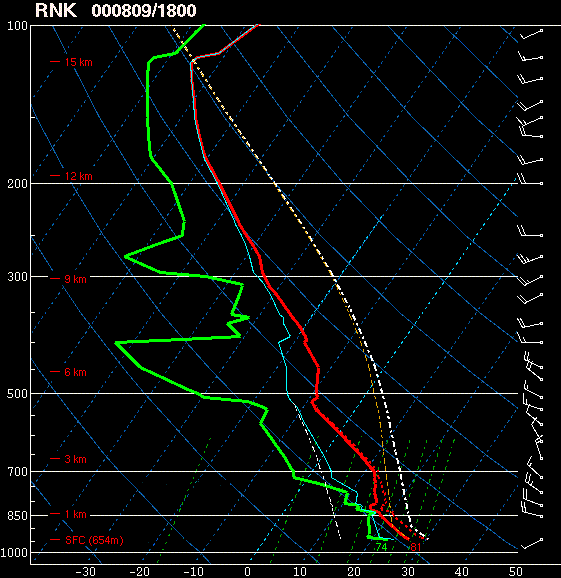
Figure 6. Sounding (radiosonde) observation made at Blacksburg, Virginia (RNK) at 2:00 p.m. EDT (1800 UTC) August 9. Standard Skew-T / Log-P plot, with temperature profile in red, moisture (dew point) in green, and winds (using barb format, as in Figure 3) in knots. Degree of thermodynamic instability is proportional area lying between the parcel ascent curve (dashed white line) and the red environmental temperature profile.
Typical of strong, travelling convective systems, the squall line associated with Derecho 1 left a large, oval-shaped "bubble" of low-level
storm outflow --- a surface cold pool --- in its wake. The cold pool marked the path taken by the convective system from Indiana into
western Virginia. By mid-afternoon the southern edge of the elongating mass of stabilized air --- the outflow boundary or gust front --- extended
from southeast Indiana through southern Ohio into southern West Virginia. This part of the outflow boundary was oriented nearly
parallel to the west-northwesterly mean tropospheric flow (recall Figures 3 and 6) and, as a result, became nearly stationary. Meanwhile, in
western Virginia, the portion of the gust front oriented more perpendicular to the flow remained progressive. By abruptly uplifting the warm,
humid air to its east, new storms continued to form along its leading edge; this part of the boundary thereby fostered the continued
east-southeast movement of Derecho 1 across central and eastern Virginia. Derecho 1 therefore well-illustrates the relationship between derecho
motion and elongating cold pools discussed here.
Derecho 2 --- Mid-afternoon through the overnight, Ohio to South Carolina
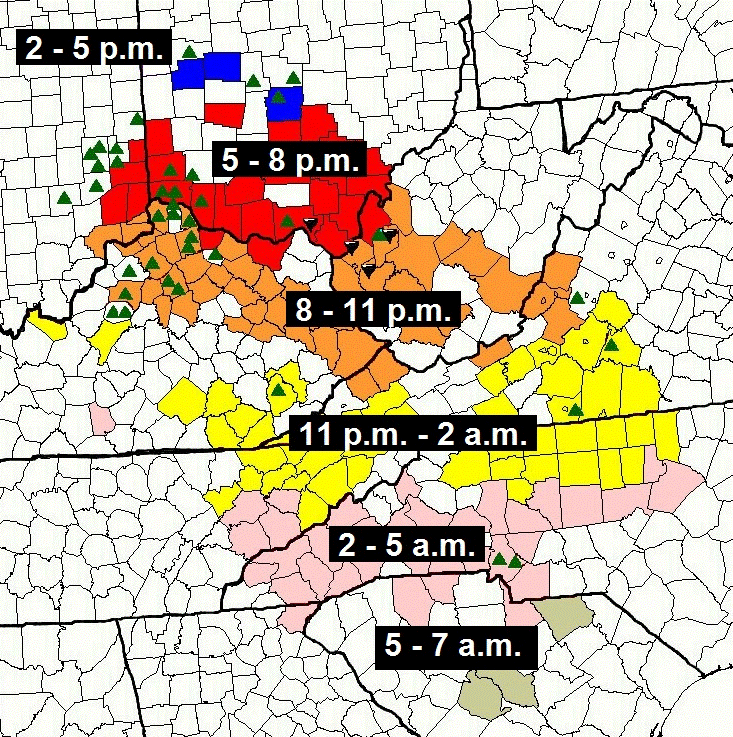
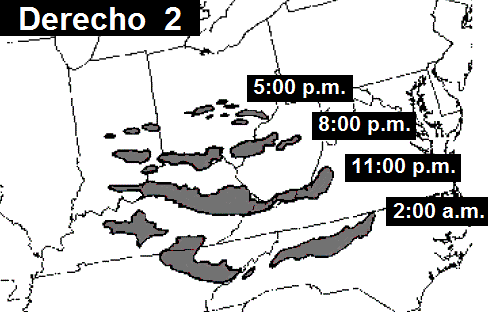
Figure 7. As for Figure 2, but for Derecho 2, with reports occuring during the 17-hour period from 2:00 p.m. EDT (1800 UTC) Wednesday, August 9 to 7:00 a.m. EDT (1100 UTC) Thursday, August 10. (Base map courtesy of S. Keighton, S. Nogueira, and N. Belk, NOAA-NWS).
In response to strong surface heating along the stalling portion of Derecho 1's outflow boundary --- and to the presence of very moist air
(surface dewpoints in the upper 70s °F) to its immediate south --- new thunderstorms began to form by mid-afternoon over parts of
Indiana and Ohio (Figure 5). Some of the initial storms were "elevated," meaning that their bases were located north of the boundary,
atop the shallow dome of cool air left by Derecho 1. As daytime heating continued, however, the storms became increasingly
"surface-based." They began to produce damaging wind and hail as new updrafts formed preferentially toward the southern (warm) side
of the boundary. At the same time, the belt of 40-50 mph west-northwesterly mid-level flow associated with the passing jet stream impulse
promoted the intensification and consolidation of storm downdrafts. This, in turn, increased the rate of new storm development, and by early
evening a nearly solid line of storms extended from south of Indianapolis to near Charleston, West Virginia (Figure 5). This squall line
--- herein referred to as Derecho 2 --- destroyed a barn and mobile home in Lawrence County, Ohio (just across the Ohio River from Huntington,
West Virginia), and produced several brief tornadoes and swaths of locally damaging wind elsewhere across southern Ohio and western
West Virginia (Figure 7).
Derecho 2 further consolidated as it moved east-southeast across the Ohio River into parts of Kentucky and southern West Virginia through
mid-evening. The eastern part of the convective system --- over western West Virginia and far eastern Kentucky --- developed a bend or inflection
known as a line echo wave pattern, or LEWP. This structure is best developed at the time of the pause in the radar animation
shown in Figure 4. LEWPs most commonly appear within serial-type derechos, those that occur in connection with strong synoptic-scale low pressure
areas during the spring and fall (a regional radar view of a serial-type derecho with several embedded LEWPS appears here).
But LEWPs also sometimes arise when a squall line such as that which might be associated with a "progressive" or warm-season-type derecho encounters
an existing boundary or front. This appears to have been the case on the evening of August 9, 2000, as a bowed part of Derecho 2 (denoting a region
locally-enhanced storm outflow) interacted with the nearly stationary outflow boundary left by Derecho 1 over south-central West Virginia. The
"crest" or inflection point of a LEWP frequently is the site of enhanced low-level storm-scale circulations, and such circulations may, in part,
have been responsible for the short-lived tornadoes that occurred in southern West Virginia shortly before sunset.
The convective system turned more south-southeastward later in the evening, reaching southwest Virginia and southeast Kentucky by 11:00 p.m.,
and northeast Tennessee and northwest North Carolina shortly after midnight. The rightward turn reflected, in part, the tendency for new storms to
accrue preferentially on the western end of the complex (i.e., over Kentucky) as the eastern part of the system encountered the area of low-level
stabilization left by the first derecho in southern Virginia. In addition, the mean environmental flow over the eastern United States was becoming
more northerly with time due to retrogression (westward motion) of the large-scale upper-level ridge over the Plains. This retrogressive motion and
its effect on mid-tropospheric winds is apparent by comparison of the 500 mb flow over the Ohio Valley in Figures 4a and 4b. The increasing
northerly component to the winds aloft contributed to more northwesterly (rather west-northwesterly)-directed low-level storm outflow. This, in turn,
shifted the strongest gust front uplift --- and the zone of most frequent new storm development --- also toward south.
Although no officially measured severe gusts were recorded, Derecho 2 continued to topple trees and power lines along its path as it moved with a
forward speed of 25-30 mph. In all, the convective system was responsible for more than 200 reports of damaging wind. Interestingly, the severe
weather continued throughout the night, epecially over upstate portions of the Carolinas --- something quite rare both seasonally and geographically .
The dual Appalachian-crossing derechos of 9-10 August 2000 illustrate that when wind and thermodynamic conditions are favorable for the development
of thunderstorms over and east of the mountains, the Appalachians are not an impenetrable barrier to the movement of derecho-producing convective
systems that arise in the Ohio Valley. On August 9-10, 2000, it appears that a moisture-rich low-level environment, together with the presence of
sufficient vertical shear to sustain convective development along existing storm outflow boundaries, enabled two mountain-crossing,
derecho-producing systems to affect the region in the same twelve-hour period. As was the case with the Ohio Valley / Mid-Atlantic
derecho of June 29, 2012, evidence also suggests that the longevity of the August 9-10, 2000 events
may have been enhanced by the Appalachians, as downslope-accelerated flow in the convective system cold pools augmented low-level
gust front uplift east of the mountains, much as discussed in this
modeling study of squall lines affected by complex terrain. In the case of Derecho 2, this process enabled viable cell propagation --- and
damaging wind gusts --- to continue throughout the night.
_____________________________________________________________________________
[Thanks to Steve Keighton, WFO Blacksburg, Virginia, who suggested including the unusual pair of August 9-10, 2000 events in "About Derechos," and for providing information on the convective systems involved.]
Additional information:
American Meteorological Society
- Conference on Weather Analysis and Forecasting (2001) preprint article on the synoptic and mesoscale aspects of the August 9, 2000
derechos by Steve Keighton, Steve Nogueira, and Nicole Belk
Blacksburg, Virginia NWS Office
- Overview of the August 9, 2000 Appalachian-crossing derechos by Steve Keighton