|
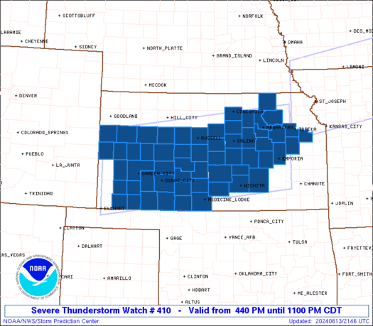
Initial List of Counties in SPC Severe Thunderstorm Watch 410 (WOU)
|
Back to Watch 410
|
 |
   WOUS64 KWNS 132138
   WOU0

   BULLETIN - IMMEDIATE BROADCAST REQUESTED
   SEVERE THUNDERSTORM WATCH OUTLINE UPDATE FOR WS 410
   NWS STORM PREDICTION CENTER NORMAN OK
   440 PM CDT THU JUN 13 2024

   SEVERE THUNDERSTORM WATCH 410 IS IN EFFECT UNTIL 1100 PM CDT
   FOR THE FOLLOWING LOCATIONS

   KSC007-009-015-017-025-027-029-033-041-045-047-051-053-055-057-
   061-063-067-069-071-079-081-083-093-095-097-101-105-109-111-113-
   115-117-119-127-135-139-143-145-149-151-155-159-161-165-167-169-
   171-173-175-177-185-189-195-197-199-203-140400-
   /O.NEW.KWNS.SV.A.0410.240613T2140Z-240614T0400Z/

   KS
   .    KANSAS COUNTIES INCLUDED ARE

   BARBER               BARTON              BUTLER
   CHASE                CLARK               CLAY
   CLOUD                COMANCHE            DICKINSON
   DOUGLAS              EDWARDS             ELLIS
   ELLSWORTH            FINNEY              FORD
   GEARY                GOVE                GRANT
   GRAY                 GREELEY             HARVEY
   HASKELL              HODGEMAN            KEARNY
   KINGMAN              KIOWA               LANE
   LINCOLN              LOGAN               LYON
   MARION               MARSHALL            MCPHERSON
   MEADE                MORRIS              NESS
   OSAGE                OTTAWA              PAWNEE
   POTTAWATOMIE         PRATT               RENO
   RICE                 RILEY               RUSH
   RUSSELL              SALINE              SCOTT
   SEDGWICK             SEWARD              SHAWNEE
   STAFFORD             STEVENS             TREGO
   WABAUNSEE            WALLACE             WICHITA


   ATTN...WFO...DDC...GLD...TOP...ICT...
|
| Aviation Watch (SAW) for WW410 |
|---|
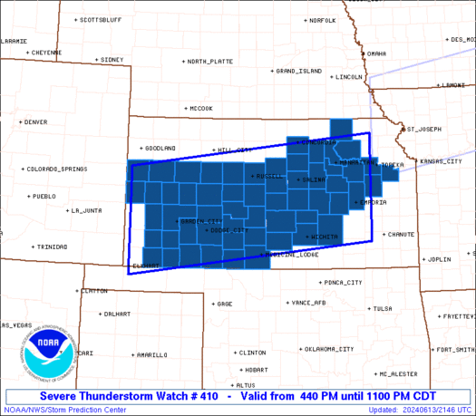 |
| Note:
The Aviation Watch (SAW) product is an approximation to the watch area.
The actual watch is depicted by the shaded areas. |
   SAW0
   WW 410 SEVERE TSTM KS 132140Z - 140400Z
   AXIS..75 STATUTE MILES NORTH AND SOUTH OF LINE..
   65W GCK/GARDEN CITY KS/ - 30NE EMP/EMPORIA KS/
   ..AVIATION COORDS.. 65NM N/S /40ESE LAA - 63SW MCI/
   HAIL SURFACE AND ALOFT..3 INCHES. WIND GUSTS..75 KNOTS.
   MAX TOPS TO 500. MEAN STORM MOTION VECTOR 29025.

   LAT...LON 39000191 39729579 37559579 36840191

   THIS IS AN APPROXIMATION TO THE WATCH AREA.  FOR A
   COMPLETE DEPICTION OF THE WATCH SEE WOUS64 KWNS
   FOR WOU0.
|
|


 @NWSSPC
