|
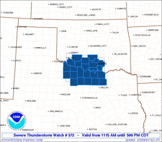
Initial List of Counties in SPC Severe Thunderstorm Watch 372 (WOU)
|
Back to Watch 372
|
 |
   WOUS64 KWNS 021614
   WOU2

   BULLETIN - IMMEDIATE BROADCAST REQUESTED
   SEVERE THUNDERSTORM WATCH OUTLINE UPDATE FOR WS 372
   NWS STORM PREDICTION CENTER NORMAN OK
   1115 AM CDT SUN JUN 2 2024

   SEVERE THUNDERSTORM WATCH 372 IS IN EFFECT UNTIL 500 PM CDT
   FOR THE FOLLOWING LOCATIONS

   OKC019-031-033-049-067-069-085-095-099-137-141-022200-
   /O.NEW.KWNS.SV.A.0372.240602T1615Z-240602T2200Z/

   OK
   .    OKLAHOMA COUNTIES INCLUDED ARE

   CARTER               COMANCHE            COTTON
   GARVIN               JEFFERSON           JOHNSTON
   LOVE                 MARSHALL            MURRAY
   STEPHENS             TILLMAN


   TXC009-023-077-085-097-121-181-237-337-485-487-497-503-022200-
   /O.NEW.KWNS.SV.A.0372.240602T1615Z-240602T2200Z/

   TX
   .    TEXAS COUNTIES INCLUDED ARE

   ARCHER               BAYLOR              CLAY
   COLLIN               COOKE               DENTON
   GRAYSON              JACK                MONTAGUE
   WICHITA              WILBARGER           WISE
   YOUNG


   ATTN...WFO...OUN...FWD...
|
| Aviation Watch (SAW) for WW372 |
|---|
 |
| Note:
The Aviation Watch (SAW) product is an approximation to the watch area.
The actual watch is depicted by the shaded areas. |
   SAW2
   WW 372 SEVERE TSTM OK TX 021615Z - 022200Z
   AXIS..60 STATUTE MILES NORTH AND SOUTH OF LINE..
   40S LTS/ALTUS OK/ - 15ENE GYI/SHERMAN TX/
   ..AVIATION COORDS.. 50NM N/S /34W SPS - 44ESE ADM/
   HAIL SURFACE AND ALOFT..2 INCHES. WIND GUSTS..60 KNOTS.
   MAX TOPS TO 500. MEAN STORM MOTION VECTOR 28020.

   LAT...LON 34939927 34669643 32939643 33209927

   THIS IS AN APPROXIMATION TO THE WATCH AREA.  FOR A
   COMPLETE DEPICTION OF THE WATCH SEE WOUS64 KWNS
   FOR WOU2.
|
|


 @NWSSPC
