|
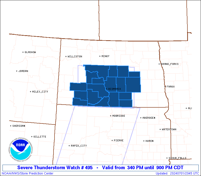
Initial List of Counties in SPC Severe Thunderstorm Watch 495 (WOU)
|
Back to Watch 495
|
 |
   WOUS64 KWNS 012038
   WOU5

   BULLETIN - IMMEDIATE BROADCAST REQUESTED
   SEVERE THUNDERSTORM WATCH OUTLINE UPDATE FOR WS 495
   NWS STORM PREDICTION CENTER NORMAN OK
   340 PM CDT MON JUL 1 2024

   SEVERE THUNDERSTORM WATCH 495 IS IN EFFECT UNTIL 900 PM CDT
   FOR THE FOLLOWING LOCATIONS

   NDC001-015-029-031-037-041-043-047-051-055-057-059-065-083-085-
   089-093-103-020200-
   /O.NEW.KWNS.SV.A.0495.240701T2040Z-240702T0200Z/

   ND
   .    NORTH DAKOTA COUNTIES INCLUDED ARE

   ADAMS                BURLEIGH            EMMONS
   FOSTER               GRANT               HETTINGER
   KIDDER               LOGAN               MCINTOSH
   MCLEAN               MERCER              MORTON
   OLIVER               SHERIDAN            SIOUX
   STARK                STUTSMAN            WELLS


   ATTN...WFO...BIS...
|
| Aviation Watch (SAW) for WW495 |
|---|
 |
| Note:
The Aviation Watch (SAW) product is an approximation to the watch area.
The actual watch is depicted by the shaded areas. |
   SAW5
   WW 495 SEVERE TSTM ND 012040Z - 020200Z
   AXIS..90 STATUTE MILES EAST AND WEST OF LINE..
   30ENE N60/GARRISON ND/ - 60S BIS/BISMARCK ND/
   ..AVIATION COORDS.. 80NM E/W /32SE MOT - 52S BIS/
   HAIL SURFACE AND ALOFT..2 INCHES. WIND GUSTS..60 KNOTS.
   MAX TOPS TO 500. MEAN STORM MOTION VECTOR 25035.

   LAT...LON 47809889 45909888 45900262 47800277

   THIS IS AN APPROXIMATION TO THE WATCH AREA.  FOR A
   COMPLETE DEPICTION OF THE WATCH SEE WOUS64 KWNS
   FOR WOU5.
|
|


 @NWSSPC