|
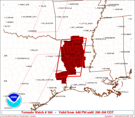
Initial List of Counties in SPC Tornado Watch 160 (WOU)
|
Back to Watch 160
|
 |
   WOUS64 KWNS 282338
   WOU0

   BULLETIN - IMMEDIATE BROADCAST REQUESTED
   TORNADO WATCH OUTLINE UPDATE FOR WT 160
   NWS STORM PREDICTION CENTER NORMAN OK
   640 PM CDT SUN APR 28 2024

   TORNADO WATCH 160 IS IN EFFECT UNTIL 200 AM CDT FOR THE
    FOLLOWING LOCATIONS

   ARC011-013-027-073-103-139-290700-
   /O.NEW.KWNS.TO.A.0160.240428T2340Z-240429T0700Z/

   AR
   .    ARKANSAS COUNTIES INCLUDED ARE

   BRADLEY              CALHOUN             COLUMBIA
   LAFAYETTE            OUACHITA            UNION


   LAC013-015-017-021-027-031-043-049-059-061-069-073-081-085-111-
   115-119-127-290700-
   /O.NEW.KWNS.TO.A.0160.240428T2340Z-240429T0700Z/

   LA
   .    LOUISIANA PARISHES INCLUDED ARE

   BIENVILLE            BOSSIER             CADDO
   CALDWELL             CLAIBORNE           DE SOTO
   GRANT                JACKSON             LA SALLE
   LINCOLN              NATCHITOCHES        OUACHITA
   RED RIVER            SABINE              UNION
   VERNON               WEBSTER             WINN


   TXC241-351-457-290700-
   /O.NEW.KWNS.TO.A.0160.240428T2340Z-240429T0700Z/

   TX
   .    TEXAS COUNTIES INCLUDED ARE

   JASPER               NEWTON              TYLER


   ATTN...WFO...LZK...LCH...SHV...
|
| Aviation Watch (SAW) for WW160 |
|---|
 |
| Note:
The Aviation Watch (SAW) product is an approximation to the watch area.
The actual watch is depicted by the shaded areas. |
   SAW0
   WW 160 TORNADO AR LA TX 282340Z - 290700Z
   AXIS..65 STATUTE MILES EAST AND WEST OF LINE..
   25N ELD/EL DORADO AR/ - 30SW POE/FORT POLK LA/
   ..AVIATION COORDS.. 55NM E/W /20NNW ELD - 42NNW LCH/
   HAIL SURFACE AND ALOFT..1.5 INCHES. WIND GUSTS..65 KNOTS.
   MAX TOPS TO 500. MEAN STORM MOTION VECTOR 24035.

   LAT...LON 33589169 30749244 30749463 33589395

   THIS IS AN APPROXIMATION TO THE WATCH AREA.  FOR A
   COMPLETE DEPICTION OF THE WATCH SEE WOUS64 KWNS
   FOR WOU0.
|
|


 @NWSSPC
