|
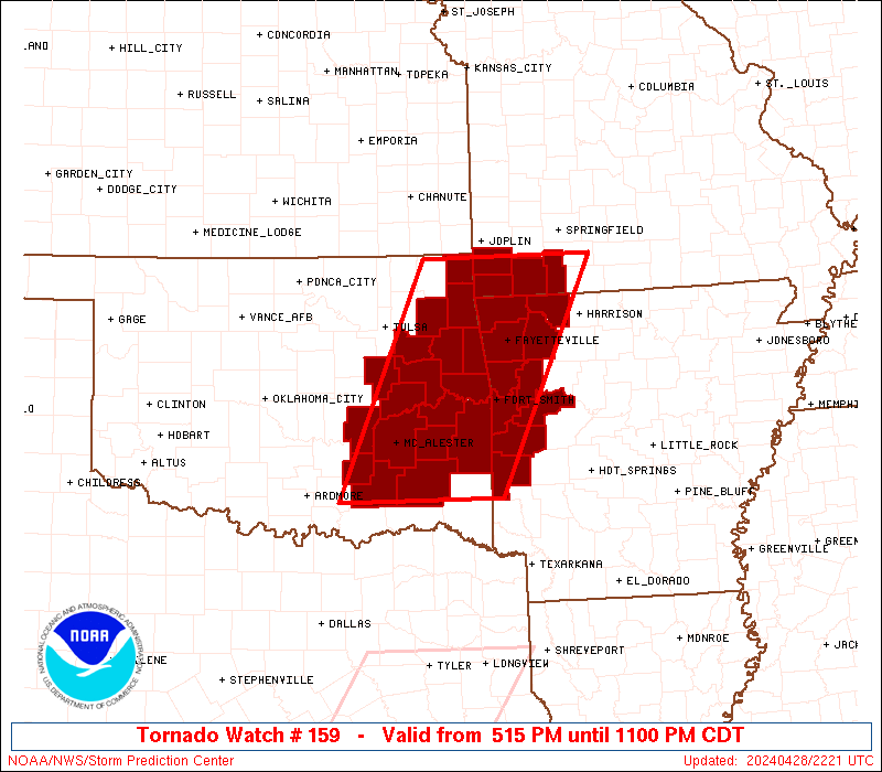
Initial List of Counties in SPC Tornado Watch 159 (WOU)
|
Back to Watch 159
|
 |
   WOUS64 KWNS 282212
   WOU9

   BULLETIN - IMMEDIATE BROADCAST REQUESTED
   TORNADO WATCH OUTLINE UPDATE FOR WT 159
   NWS STORM PREDICTION CENTER NORMAN OK
   515 PM CDT SUN APR 28 2024

   TORNADO WATCH 159 IS IN EFFECT UNTIL 1100 PM CDT FOR THE
    FOLLOWING LOCATIONS

   ARC007-015-033-047-083-087-113-127-131-143-290400-
   /O.NEW.KWNS.TO.A.0159.240428T2215Z-240429T0400Z/

   AR
   .    ARKANSAS COUNTIES INCLUDED ARE

   BENTON               CARROLL             CRAWFORD
   FRANKLIN             LOGAN               MADISON
   POLK                 SCOTT               SEBASTIAN
   WASHINGTON


   MOC009-119-145-209-290400-
   /O.NEW.KWNS.TO.A.0159.240428T2215Z-240429T0400Z/

   MO
   .    MISSOURI COUNTIES INCLUDED ARE

   BARRY                MCDONALD            NEWTON
   STONE


   OKC001-005-021-029-041-061-063-077-079-091-097-101-111-115-121-
   127-135-145-290400-
   /O.NEW.KWNS.TO.A.0159.240428T2215Z-240429T0400Z/

   OK
   .    OKLAHOMA COUNTIES INCLUDED ARE

   ADAIR                ATOKA               CHEROKEE
   COAL                 DELAWARE            HASKELL
   HUGHES               LATIMER             LE FLORE
   MAYES                MCINTOSH            MUSKOGEE
   OKMULGEE             OTTAWA              PITTSBURG
   PUSHMATAHA           SEQUOYAH            WAGONER


   ATTN...WFO...TSA...OUN...SGF...LZK...
|
| Aviation Watch (SAW) for WW159 |
|---|
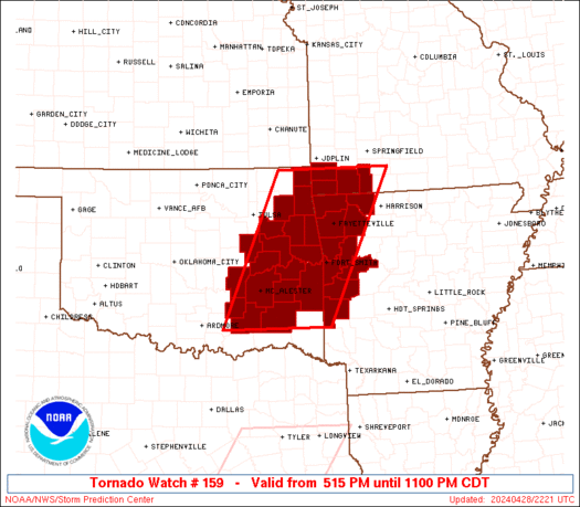 |
| Note:
The Aviation Watch (SAW) product is an approximation to the watch area.
The actual watch is depicted by the shaded areas. |
   SAW9
   WW 159 TORNADO AR MO OK 282215Z - 290400Z
   AXIS..65 STATUTE MILES EAST AND WEST OF LINE..
   15WNW UMN/MONETT MO/ - 50SSE MLC/MCALESTER OK/
   ..AVIATION COORDS.. 55NM E/W /43N RZC - 42SSE MLC/
   HAIL SURFACE AND ALOFT..1.5 INCHES. WIND GUSTS..60 KNOTS.
   MAX TOPS TO 400. MEAN STORM MOTION VECTOR 23030.

   LAT...LON 36969297 34219431 34219658 36969533

   THIS IS AN APPROXIMATION TO THE WATCH AREA.  FOR A
   COMPLETE DEPICTION OF THE WATCH SEE WOUS64 KWNS
   FOR WOU9.
|
|


 @NWSSPC