|
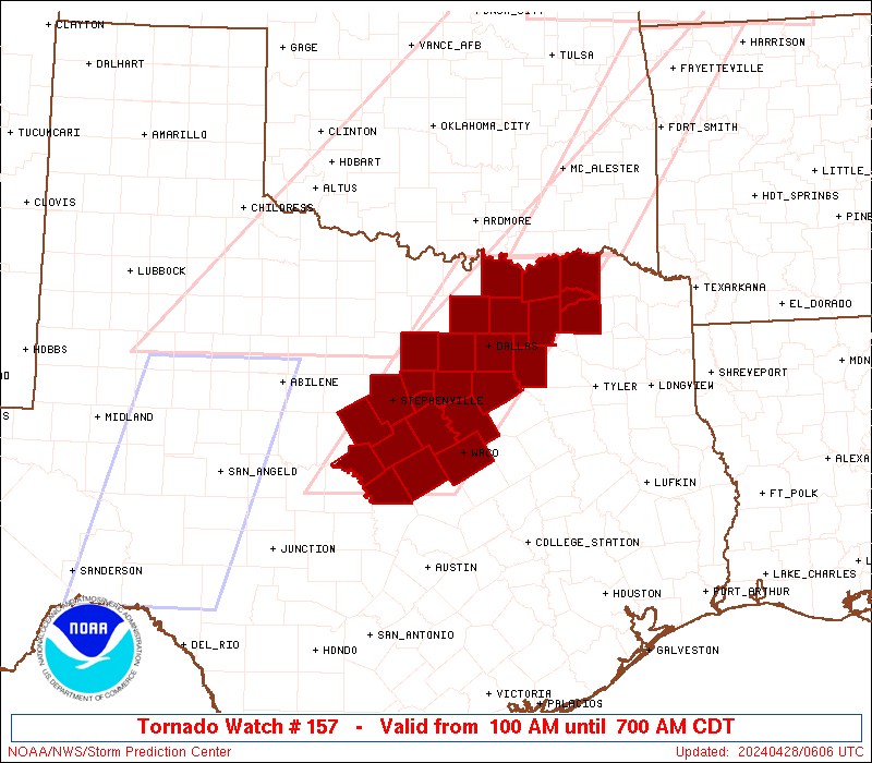
Initial List of Counties in SPC Tornado Watch 157 (WOU)
|
Back to Watch 157
|
 |
   WOUS64 KWNS 280557
   WOU7

   BULLETIN - IMMEDIATE BROADCAST REQUESTED
   TORNADO WATCH OUTLINE UPDATE FOR WT 157
   NWS STORM PREDICTION CENTER NORMAN OK
   100 AM CDT SUN APR 28 2024

   TORNADO WATCH 157 IS IN EFFECT UNTIL 700 AM CDT FOR THE
    FOLLOWING LOCATIONS

   TXC035-085-093-099-113-119-121-139-143-147-181-193-217-221-223-
   231-251-257-277-281-309-333-367-397-425-439-281200-
   /O.NEW.KWNS.TO.A.0157.240428T0600Z-240428T1200Z/

   TX
   .    TEXAS COUNTIES INCLUDED ARE

   BOSQUE               COLLIN              COMANCHE
   CORYELL              DALLAS              DELTA
   DENTON               ELLIS               ERATH
   FANNIN               GRAYSON             HAMILTON
   HILL                 HOOD                HOPKINS
   HUNT                 JOHNSON             KAUFMAN
   LAMAR                LAMPASAS            MCLENNAN
   MILLS                PARKER              ROCKWALL
   SOMERVELL            TARRANT


   ATTN...WFO...FWD...
|
| Aviation Watch (SAW) for WW157 |
|---|
 |
| Note:
The Aviation Watch (SAW) product is an approximation to the watch area.
The actual watch is depicted by the shaded areas. |
   SAW7
   WW 157 TORNADO TX 280600Z - 281200Z
   AXIS..60 STATUTE MILES EAST AND WEST OF LINE..
   30ENE GYI/SHERMAN TX/ - 55W TPL/TEMPLE TX/
   ..AVIATION COORDS.. 50NM E/W /53ESE ADM - 63NW CWK/
   HAIL SURFACE AND ALOFT..1 INCH. WIND GUSTS..60 KNOTS.
   MAX TOPS TO 550. MEAN STORM MOTION VECTOR 27035.

   LAT...LON 33889514 31149734 31149936 33889723

   THIS IS AN APPROXIMATION TO THE WATCH AREA.  FOR A
   COMPLETE DEPICTION OF THE WATCH SEE WOUS64 KWNS
   FOR WOU7.
|
|


 @NWSSPC