|
Initial List of Counties in SPC Severe Thunderstorm Watch 148 (WOU)
|
Back to Watch 148
|
 |
WOUS64 KWNS 271952
WOU8
BULLETIN - IMMEDIATE BROADCAST REQUESTED
SEVERE THUNDERSTORM WATCH OUTLINE UPDATE FOR WS 148
NWS STORM PREDICTION CENTER NORMAN OK
255 PM CDT SAT APR 27 2024
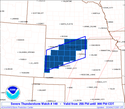
SEVERE THUNDERSTORM WATCH 148 IS IN EFFECT UNTIL 900 PM CDT
FOR THE FOLLOWING LOCATIONS
KSC051-055-063-065-071-075-089-093-101-109-123-135-137-141-147-
163-165-171-179-183-187-195-203-280200-
/O.NEW.KWNS.SV.A.0148.240427T1955Z-240428T0200Z/
KS
. KANSAS COUNTIES INCLUDED ARE
ELLIS FINNEY GOVE
GRAHAM GREELEY HAMILTON
JEWELL KEARNY LANE
LOGAN MITCHELL NESS
NORTON OSBORNE PHILLIPS
ROOKS RUSH SCOTT
SHERIDAN SMITH STANTON
TREGO WICHITA
ATTN...WFO...DDC...GLD...GID...
|
| Aviation Watch (SAW) for WW148 |
|---|
 |
| Note:
The Aviation Watch (SAW) product is an approximation to the watch area.
The actual watch is depicted by the shaded areas. |
   SAW8
   WW 148 SEVERE TSTM KS 271955Z - 280200Z
   AXIS..55 STATUTE MILES NORTH AND SOUTH OF LINE..
   70WNW GCK/GARDEN CITY KS/ - 55NE RSL/RUSSELL KS/
   ..AVIATION COORDS.. 50NM N/S /37E LAA - 37NW SLN/
   HAIL SURFACE AND ALOFT..2 INCHES. WIND GUSTS..60 KNOTS.
   MAX TOPS TO 500. MEAN STORM MOTION VECTOR 24035.

   LAT...LON 39110191 40229809 38629809 37520191

   THIS IS AN APPROXIMATION TO THE WATCH AREA.  FOR A
   COMPLETE DEPICTION OF THE WATCH SEE WOUS64 KWNS
   FOR WOU8.
|
|


 @NWSSPC
