|
Initial List of Counties in SPC Tornado Watch 145 (WOU)
|
Back to Watch 145
|
 |
WOUS64 KWNS 271649
WOU5
BULLETIN - IMMEDIATE BROADCAST REQUESTED
TORNADO WATCH OUTLINE UPDATE FOR WT 145
NWS STORM PREDICTION CENTER NORMAN OK
1150 AM CDT SAT APR 27 2024
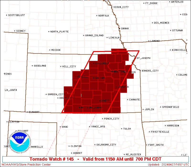
TORNADO WATCH 145 IS IN EFFECT UNTIL 700 PM CDT FOR THE
FOLLOWING LOCATIONS
KSC007-009-013-015-017-019-027-029-031-033-035-041-045-047-049-
053-061-073-077-079-085-087-095-097-105-111-113-115-117-127-131-
139-143-145-149-151-155-159-161-167-169-173-177-185-191-197-201-
280000-
/O.NEW.KWNS.TO.A.0145.240427T1650Z-240428T0000Z/
KS
. KANSAS COUNTIES INCLUDED ARE
BARBER BARTON BROWN
BUTLER CHASE CHAUTAUQUA
CLAY CLOUD COFFEY
COMANCHE COWLEY DICKINSON
DOUGLAS EDWARDS ELK
ELLSWORTH GEARY GREENWOOD
HARPER HARVEY JACKSON
JEFFERSON KINGMAN KIOWA
LINCOLN LYON MARION
MARSHALL MCPHERSON MORRIS
NEMAHA OSAGE OTTAWA
PAWNEE POTTAWATOMIE PRATT
RENO RICE RILEY
RUSSELL SALINE SEDGWICK
SHAWNEE STAFFORD SUMNER
WABAUNSEE WASHINGTON
NEC133-147-280000-
/O.NEW.KWNS.TO.A.0145.240427T1650Z-240428T0000Z/
NE
. NEBRASKA COUNTIES INCLUDED ARE
PAWNEE RICHARDSON
ATTN...WFO...DDC...OAX...TOP...ICT...
|
| Aviation Watch (SAW) for WW145 |
|---|
 |
| Note:
The Aviation Watch (SAW) product is an approximation to the watch area.
The actual watch is depicted by the shaded areas. |
   SAW5
   WW 145 TORNADO KS NE 271650Z - 280000Z
   AXIS..80 STATUTE MILES EAST AND WEST OF LINE..
   70WNW STJ/SAINT JOSEPH MO/ - 25SE P28/MEDICINE LODGE KS/
   ..AVIATION COORDS.. 70NM E/W /4SE PWE - 44NNW END/
   HAIL SURFACE AND ALOFT..2.5 INCHES. WIND GUSTS..65 KNOTS.
   MAX TOPS TO 500. MEAN STORM MOTION VECTOR 25030.

   LAT...LON 40149463 37029681 37029971 40149766

   THIS IS AN APPROXIMATION TO THE WATCH AREA.  FOR A
   COMPLETE DEPICTION OF THE WATCH SEE WOUS64 KWNS
   FOR WOU5.
|
|


 @NWSSPC