|
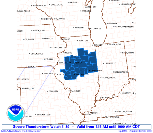
Initial List of Counties in SPC Severe Thunderstorm Watch 39 (WOU)
|
Back to Watch 39
|
 |
   WOUS64 KWNS 140814
   WOU9

   BULLETIN - IMMEDIATE BROADCAST REQUESTED
   SEVERE THUNDERSTORM WATCH OUTLINE UPDATE FOR WS 39
   NWS STORM PREDICTION CENTER NORMAN OK
   315 AM CDT THU MAR 14 2024

   SEVERE THUNDERSTORM WATCH 39 IS IN EFFECT UNTIL 1000 AM CDT
   FOR THE FOLLOWING LOCATIONS

   ILC017-019-039-053-057-063-075-091-095-099-105-107-113-115-123-
   125-129-137-143-147-167-169-171-175-179-183-203-141500-
   /O.NEW.KWNS.SV.A.0039.240314T0815Z-240314T1500Z/

   IL
   .    ILLINOIS COUNTIES INCLUDED ARE

   CASS                 CHAMPAIGN           DE WITT
   FORD                 FULTON              GRUNDY
   IROQUOIS             KANKAKEE            KNOX
   LA SALLE             LIVINGSTON          LOGAN
   MACON                MARSHALL            MASON
   MCLEAN               MENARD              MORGAN
   PEORIA               PIATT               SANGAMON
   SCHUYLER             SCOTT               STARK
   TAZEWELL             VERMILION           WOODFORD


   ATTN...WFO...ILX...LOT...
|
| Aviation Watch (SAW) for WW39 |
|---|
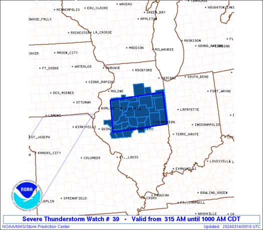 |
| Note:
The Aviation Watch (SAW) product is an approximation to the watch area.
The actual watch is depicted by the shaded areas. |
   SAW9
   WW 39 SEVERE TSTM IL 140815Z - 141500Z
   AXIS..45 STATUTE MILES NORTH AND SOUTH OF LINE..
   45WSW PIA/PEORIA IL/ - 50NE CMI/CHAMPAIGN IL/
   ..AVIATION COORDS.. 40NM N/S /50NE UIN - 25W BVT/
   HAIL SURFACE AND ALOFT..2 INCHES. WIND GUSTS..60 KNOTS.
   MAX TOPS TO 450. MEAN STORM MOTION VECTOR 26040.

   LAT...LON 41079047 41198761 39898761 39779047

   THIS IS AN APPROXIMATION TO THE WATCH AREA.  FOR A
   COMPLETE DEPICTION OF THE WATCH SEE WOUS64 KWNS
   FOR WOU9.
|
|


 @NWSSPC
