Note:
The expiration time in the watch graphic is amended if the watch is
replaced, cancelled or extended.
Note:
Note:
The expiration time in the watch graphic is amended if the watch is
replaced, cancelled or extended.
Note: Click for
Watch Status Reports.
SEL0
URGENT - IMMEDIATE BROADCAST REQUESTED
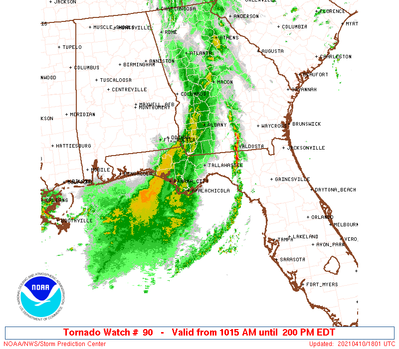
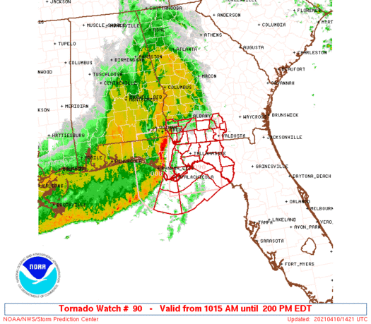
Tornado Watch Number 90
NWS Storm Prediction Center Norman OK
1015 AM EDT Sat Apr 10 2021
The NWS Storm Prediction Center has issued a
* Tornado Watch for portions of
The eastern Florida Panhandle
Extreme southwestern Georgia
Coastal Waters
* Effective this Saturday morning and afternoon from 1015 AM
until 200 PM EDT.
* Primary threats include...
A couple tornadoes possible
Scattered damaging wind gusts to 70 mph possible
Isolated large hail events to 1 inch in diameter possible
SUMMARY...A well-developed squall line will continue to surge
eastward across the Florida Panhandle and southwestern Georgia
through midday into early afternoon. Given the observed bowing
structures and embedded circulations, expect the threat for a few
damaging gusts and a couple of tornadoes to continue for the next
few hours.
The tornado watch area is approximately along and 55 statute miles
east and west of a line from 25 miles northwest of Moultrie GA to 55
miles southeast of Apalachicola FL. For a complete depiction of the
watch see the associated watch outline update (WOUS64 KWNS WOU0).
PRECAUTIONARY/PREPAREDNESS ACTIONS...
REMEMBER...A Tornado Watch means conditions are favorable for
tornadoes and severe thunderstorms in and close to the watch
area. Persons in these areas should be on the lookout for
threatening weather conditions and listen for later statements
and possible warnings.
&&
AVIATION...Tornadoes and a few severe thunderstorms with hail
surface and aloft to 1 inch. Extreme turbulence and surface wind
gusts to 60 knots. A few cumulonimbi with maximum tops to 500. Mean
storm motion vector 27045.
...Thompson
   SEL0

   URGENT - IMMEDIATE BROADCAST REQUESTED
   Tornado Watch Number 90
   NWS Storm Prediction Center Norman OK
   1015 AM EDT Sat Apr 10 2021

   The NWS Storm Prediction Center has issued a

   * Tornado Watch for portions of
     The eastern Florida Panhandle
     Extreme southwestern Georgia
     Coastal Waters

   * Effective this Saturday morning and afternoon from 1015 AM
     until 200 PM EDT.

   * Primary threats include...
     A couple tornadoes possible
     Scattered damaging wind gusts to 70 mph possible
     Isolated large hail events to 1 inch in diameter possible

   SUMMARY...A well-developed squall line will continue to surge
   eastward across the Florida Panhandle and southwestern Georgia
   through midday into early afternoon.  Given the observed bowing
   structures and embedded circulations, expect the threat for a few
   damaging gusts and a couple of tornadoes to continue for the next
   few hours.

   The tornado watch area is approximately along and 55 statute miles
   east and west of a line from 25 miles northwest of Moultrie GA to 55
   miles southeast of Apalachicola FL. For a complete depiction of the
   watch see the associated watch outline update (WOUS64 KWNS WOU0).

   PRECAUTIONARY/PREPAREDNESS ACTIONS...

   REMEMBER...A Tornado Watch means conditions are favorable for
   tornadoes and severe thunderstorms in and close to the watch
   area. Persons in these areas should be on the lookout for
   threatening weather conditions and listen for later statements
   and possible warnings.

   &&

   AVIATION...Tornadoes and a few severe thunderstorms with hail
   surface and aloft to 1 inch. Extreme turbulence and surface wind
   gusts to 60 knots. A few cumulonimbi with maximum tops to 500. Mean
   storm motion vector 27045.

   ...Thompson
 Note:
The Aviation Watch (SAW) product is an approximation to the watch area.
The actual watch is depicted by the shaded areas.
Note:
The Aviation Watch (SAW) product is an approximation to the watch area.
The actual watch is depicted by the shaded areas.
   SAW0
   WW 90 TORNADO FL GA CW 101415Z - 101800Z
   AXIS..55 STATUTE MILES EAST AND WEST OF LINE..
   25NW MGR/MOULTRIE GA/ - 55SE AAF/APALACHICOLA FL/
   ..AVIATION COORDS.. 50NM E/W /22SSE PZD - 75WSW CTY/
   HAIL SURFACE AND ALOFT..1 INCH. WIND GUSTS..60 KNOTS.
   MAX TOPS TO 500. MEAN STORM MOTION VECTOR 27045.

   LAT...LON 31338317 29168347 29168530 31338503

   THIS IS AN APPROXIMATION TO THE WATCH AREA.  FOR A
   COMPLETE DEPICTION OF THE WATCH SEE WOUS64 KWNS
   FOR WOU0.
Watch 90 Status Report Message has not been issued yet.
Note:
Click for Complete Product Text.
Tornadoes
Probability of 2 or more tornadoes
|
Mod (30%)
|
Probability of 1 or more strong (EF2-EF5) tornadoes
|
Low (10%)
|
Wind
Probability of 10 or more severe wind events
|
Mod (40%)
|
Probability of 1 or more wind events > 65 knots
|
Low (20%)
|
Hail
Probability of 10 or more severe hail events
|
Low (20%)
|
Probability of 1 or more hailstones > 2 inches
|
Low (10%)
|
Combined Severe Hail/Wind
Probability of 6 or more combined severe hail/wind events
|
Mod (60%)
|
For each watch, probabilities for particular events inside the watch
(listed above in each table) are determined by the issuing forecaster.
The "Low" category contains probability values ranging from less than 2%
to 20% (EF2-EF5 tornadoes), less than 5% to 20% (all other probabilities),
"Moderate" from 30% to 60%, and "High" from 70% to greater than 95%.
High values are bolded and lighter in color to provide awareness of
an increased threat for a particular event.


 @NWSSPC