|
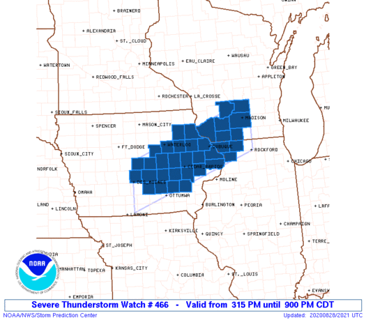
Initial List of Counties in SPC Severe Thunderstorm Watch 466 (WOU)
|
Back to Watch 466
|
 |
   WOUS64 KWNS 282013
   WOU6

   BULLETIN - IMMEDIATE BROADCAST REQUESTED
   SEVERE THUNDERSTORM WATCH OUTLINE UPDATE FOR WS 466
   NWS STORM PREDICTION CENTER NORMAN OK
   315 PM CDT FRI AUG 28 2020

   SEVERE THUNDERSTORM WATCH 466 IS IN EFFECT UNTIL 900 PM CDT
   FOR THE FOLLOWING LOCATIONS

   IAC011-013-019-031-043-045-055-061-065-075-095-097-099-103-105-
   107-113-123-125-127-153-157-169-171-183-290200-
   /O.NEW.KWNS.SV.A.0466.200828T2015Z-200829T0200Z/

   IA
   .    IOWA COUNTIES INCLUDED ARE

   BENTON               BLACK HAWK          BUCHANAN
   CEDAR                CLAYTON             CLINTON
   DELAWARE             DUBUQUE             FAYETTE
   GRUNDY               IOWA                JACKSON
   JASPER               JOHNSON             JONES
   KEOKUK               LINN                MAHASKA
   MARION               MARSHALL            POLK
   POWESHIEK            STORY               TAMA
   WASHINGTON


   ILC015-085-177-290200-
   /O.NEW.KWNS.SV.A.0466.200828T2015Z-200829T0200Z/

   IL
   .    ILLINOIS COUNTIES INCLUDED ARE

   CARROLL              JO DAVIESS          STEPHENSON


   WIC021-025-043-045-049-065-111-290200-
   /O.NEW.KWNS.SV.A.0466.200828T2015Z-200829T0200Z/

   WI
   .    WISCONSIN COUNTIES INCLUDED ARE

   COLUMBIA             DANE                GRANT
   GREEN                IOWA                LAFAYETTE
   SAUK


   ATTN...WFO...DVN...MKX...ARX...DMX...
|
| Aviation Watch (SAW) for WW466 |
|---|
 |
| Note:
The Aviation Watch (SAW) product is an approximation to the watch area.
The actual watch is depicted by the shaded areas. |
   SAW6
   WW 466 SEVERE TSTM IA IL WI 282015Z - 290200Z
   AXIS..50 STATUTE MILES NORTH AND SOUTH OF LINE..
   10S DSM/DES MOINES IA/ - 20SE MSN/MADISON WI/
   ..AVIATION COORDS.. 45NM N/S /3SSW DSM - 36WSW BAE/
   HAIL SURFACE AND ALOFT..2 INCHES. WIND GUSTS..60 KNOTS.
   MAX TOPS TO 500. MEAN STORM MOTION VECTOR 29035.

   LAT...LON 42119367 43658905 42208905 40669367

   THIS IS AN APPROXIMATION TO THE WATCH AREA.  FOR A
   COMPLETE DEPICTION OF THE WATCH SEE WOUS64 KWNS
   FOR WOU6.
|
|


 @NWSSPC
