|
Initial List of Counties in SPC PDS Tornado Watch 360 (WOU)
|
Back to Watch 360
|
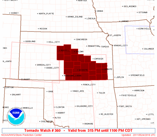 |
   WOUS64 KWNS 242011
   WOU0

   BULLETIN - IMMEDIATE BROADCAST REQUESTED
   TORNADO WATCH OUTLINE UPDATE FOR WT 360
   NWS STORM PREDICTION CENTER NORMAN OK
   315 PM CDT TUE MAY 24 2011

   TORNADO WATCH 360 IS IN EFFECT UNTIL 1100 PM CDT FOR THE
    FOLLOWING LOCATIONS

   KSC001-009-015-017-019-035-049-053-073-077-079-095-099-105-113-
   115-125-133-155-159-167-169-173-191-205-207-250400-
   /O.NEW.KWNS.TO.A.0360.110524T2015Z-110525T0400Z/

   KS
   .    KANSAS COUNTIES INCLUDED ARE

   ALLEN                BARTON              BUTLER
   CHASE                CHAUTAUQUA          COWLEY
   ELK                  ELLSWORTH           GREENWOOD
   HARPER               HARVEY              KINGMAN
   LABETTE              LINCOLN             MARION
   MCPHERSON            MONTGOMERY          NEOSHO
   RENO                 RICE                RUSSELL
   SALINE               SEDGWICK            SUMNER
   WILSON               WOODSON


   ATTN...WFO...ICT...
|
| Aviation Watch (SAW) for WW360 |
|---|
 |
| Note:
The Aviation Watch (SAW) product is an approximation to the watch area.
The actual watch is depicted by the shaded areas. |
   SAW0
   WW 360 TORNADO KS 242015Z - 250400Z
   AXIS..55 STATUTE MILES NORTH AND SOUTH OF LINE..
   40NNW P28/MEDICINE LODGE KS/ - 20ENE CNU/CHANUTE KS/
   ..AVIATION COORDS.. 50NM N/S /61W ICT - 38N OSW/
   HAIL SURFACE AND ALOFT..2.5 INCHES. WIND GUSTS..60 KNOTS.
   MAX TOPS TO 500. MEAN STORM MOTION VECTOR 24035.

   LAT...LON 38619886 38589513 36979513 37029886

   THIS IS AN APPROXIMATION TO THE WATCH AREA.  FOR A
   COMPLETE DEPICTION OF THE WATCH SEE WOUS64 KWNS
   FOR WOU0.
|
|


 @NWSSPC
