|
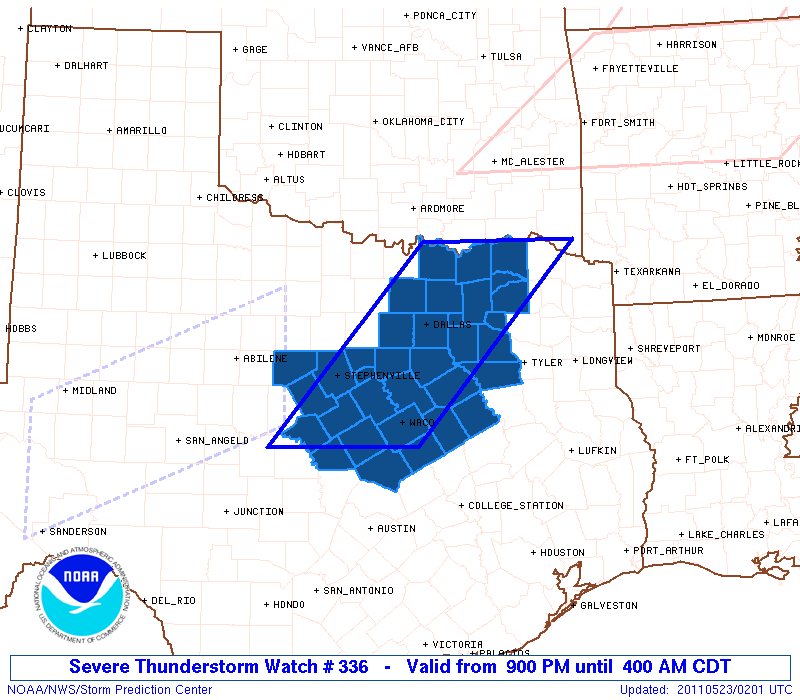
Initial List of Counties in SPC Severe Thunderstorm Watch 336 (WOU)
|
Back to Watch 336
|
 |
   WOUS64 KWNS 230155
   WOU6

   BULLETIN - IMMEDIATE BROADCAST REQUESTED
   SEVERE THUNDERSTORM WATCH OUTLINE UPDATE FOR WS 336
   NWS STORM PREDICTION CENTER NORMAN OK
   900 PM CDT SUN MAY 22 2011

   SEVERE THUNDERSTORM WATCH 336 IS IN EFFECT UNTIL 400 AM CDT
   FOR THE FOLLOWING LOCATIONS

   TXC027-035-085-093-099-113-119-121-133-139-143-145-147-161-181-
   193-213-217-221-223-231-251-257-277-281-293-309-333-349-379-397-
   425-439-467-230900-
   /O.NEW.KWNS.SV.A.0336.110523T0200Z-110523T0900Z/

   TX
   .    TEXAS COUNTIES INCLUDED ARE

   BELL                 BOSQUE              COLLIN
   COMANCHE             CORYELL             DALLAS
   DELTA                DENTON              EASTLAND
   ELLIS                ERATH               FALLS
   FANNIN               FREESTONE           GRAYSON
   HAMILTON             HENDERSON           HILL
   HOOD                 HOPKINS             HUNT
   JOHNSON              KAUFMAN             LAMAR
   LAMPASAS             LIMESTONE           MCLENNAN
   MILLS                NAVARRO             RAINS
   ROCKWALL             SOMERVELL           TARRANT
   VAN ZANDT


   ATTN...WFO...FWD...
|
| Aviation Watch (SAW) for WW336 |
|---|
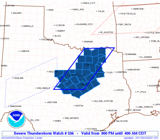 |
| Note:
The Aviation Watch (SAW) product is an approximation to the watch area.
The actual watch is depicted by the shaded areas. |
   SAW6
   WW 336 SEVERE TSTM TX 230200Z - 230900Z
   AXIS..65 STATUTE MILES EAST AND WEST OF LINE..
   25NW PRX/PARIS TX/ - 55WSW ACT/WACO TX/
   ..AVIATION COORDS.. 55NM E/W /58S MLC - 47WSW ACT/
   HAIL SURFACE AND ALOFT..2.5 INCHES. WIND GUSTS..60 KNOTS.
   MAX TOPS TO 550. MEAN STORM MOTION VECTOR 29025.

   LAT...LON 33889462 31309698 31309919 33889688

   THIS IS AN APPROXIMATION TO THE WATCH AREA.  FOR A
   COMPLETE DEPICTION OF THE WATCH SEE WOUS64 KWNS
   FOR WOU6.
|
|


 @NWSSPC