|
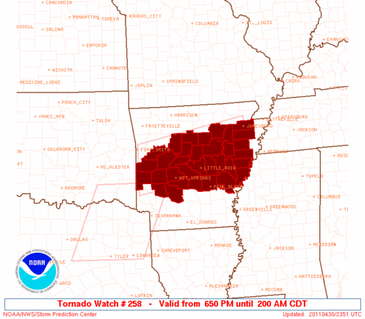
Initial List of Counties in SPC Tornado Watch 258 (WOU)
|
Back to Watch 258
|
 |
   WOUS64 KWNS 302346
   WOU8

   BULLETIN - IMMEDIATE BROADCAST REQUESTED
   TORNADO WATCH OUTLINE UPDATE FOR WT 258
   NWS STORM PREDICTION CENTER NORMAN OK
   650 PM CDT SAT APR 30 2011

   TORNADO WATCH 258 IS IN EFFECT UNTIL 200 AM CDT FOR THE
    FOLLOWING LOCATIONS

   ARC001-019-023-029-031-037-045-051-053-059-063-067-069-077-083-
   085-095-097-105-107-109-111-113-115-117-119-123-125-127-141-145-
   147-149-010700-
   /O.NEW.KWNS.TO.A.0258.110430T2350Z-110501T0700Z/

   AR
   .    ARKANSAS COUNTIES INCLUDED ARE

   ARKANSAS             CLARK               CLEBURNE
   CONWAY               CRAIGHEAD           CROSS
   FAULKNER             GARLAND             GRANT
   HOT SPRING           INDEPENDENCE        JACKSON
   JEFFERSON            LEE                 LOGAN
   LONOKE               MONROE              MONTGOMERY
   PERRY                PHILLIPS            PIKE
   POINSETT             POLK                POPE
   PRAIRIE              PULASKI             SALINE
   SCOTT                ST. FRANCIS         VAN BUREN
   WHITE                WOODRUFF            YELL


   ATTN...WFO...LZK...MEG...
|
| Aviation Watch (SAW) for WW258 |
|---|
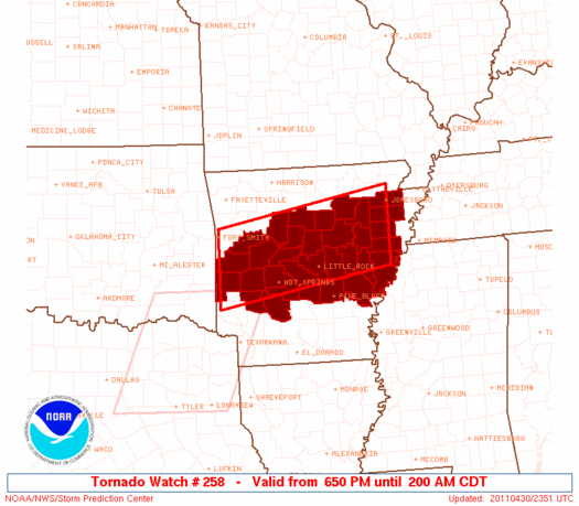 |
| Note:
The Aviation Watch (SAW) product is an approximation to the watch area.
The actual watch is depicted by the shaded areas. |
   SAW8
   WW 258 TORNADO AR 302350Z - 010700Z
   AXIS..50 STATUTE MILES NORTH AND SOUTH OF LINE..
   40S FSM/FORT SMITH AR/ - 30S JBR/JONESBORO AR/
   ..AVIATION COORDS.. 45NM N/S /38S FSM - 39WNW MEM/
   HAIL SURFACE AND ALOFT..2 INCHES. WIND GUSTS..60 KNOTS.
   MAX TOPS TO 500. MEAN STORM MOTION VECTOR 24030.

   LAT...LON 35479437 36119065 34669065 34029437

   THIS IS AN APPROXIMATION TO THE WATCH AREA.  FOR A
   COMPLETE DEPICTION OF THE WATCH SEE WOUS64 KWNS
   FOR WOU8.
|
|


 @NWSSPC
