|
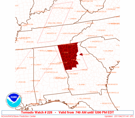
Initial List of Counties in SPC Tornado Watch 228 (WOU)
|
Back to Watch 228
|
 |
   WOUS64 KWNS 271138
   WOU8

   BULLETIN - IMMEDIATE BROADCAST REQUESTED
   TORNADO WATCH OUTLINE UPDATE FOR WT 228
   NWS STORM PREDICTION CENTER NORMAN OK
   740 AM EDT WED APR 27 2011

   TORNADO WATCH 228 IS IN EFFECT UNTIL 1200 PM EDT FOR THE
    FOLLOWING LOCATIONS

   GAC015-035-045-047-055-057-059-063-067-077-083-085-089-097-111-
   113-115-117-121-123-129-135-139-143-149-151-171-187-199-213-223-
   227-231-233-247-255-281-285-291-295-311-313-271600-
   /O.NEW.KWNS.TO.A.0228.110427T1140Z-110427T1600Z/

   GA
   .    GEORGIA COUNTIES INCLUDED ARE

   BARTOW               BUTTS               CARROLL
   CATOOSA              CHATTOOGA           CHEROKEE
   CLARKE               CLAYTON             COBB
   COWETA               DADE                DAWSON
   DEKALB               DOUGLAS             FANNIN
   FAYETTE              FLOYD               FORSYTH
   FULTON               GILMER              GORDON
   GWINNETT             HALL                HARALSON
   HEARD                HENRY               LAMAR
   LUMPKIN              MERIWETHER          MURRAY
   PAULDING             PICKENS             PIKE
   POLK                 ROCKDALE            SPALDING
   TOWNS                TROUP               UNION
   WALKER               WHITE               WHITFIELD


   ATTN...WFO...FFC...
|
| Aviation Watch (SAW) for WW228 |
|---|
 |
| Note:
The Aviation Watch (SAW) product is an approximation to the watch area.
The actual watch is depicted by the shaded areas. |
   SAW8
   WW 228 TORNADO GA 271140Z - 271600Z
   AXIS..65 STATUTE MILES EAST AND WEST OF LINE..
   50NNE RMG/ROME GA/ - 25W MCN/MACON GA/
   ..AVIATION COORDS.. 55NM E/W /16ENE GQO - 22W MCN/
   HAIL SURFACE AND ALOFT..1 INCH. WIND GUSTS..60 KNOTS.
   MAX TOPS TO 500. MEAN STORM MOTION VECTOR 26050.

   LAT...LON 35008368 32688295 32688519 35008598

   THIS IS AN APPROXIMATION TO THE WATCH AREA.  FOR A
   COMPLETE DEPICTION OF THE WATCH SEE WOUS64 KWNS
   FOR WOU8.
|
|


 @NWSSPC
