|
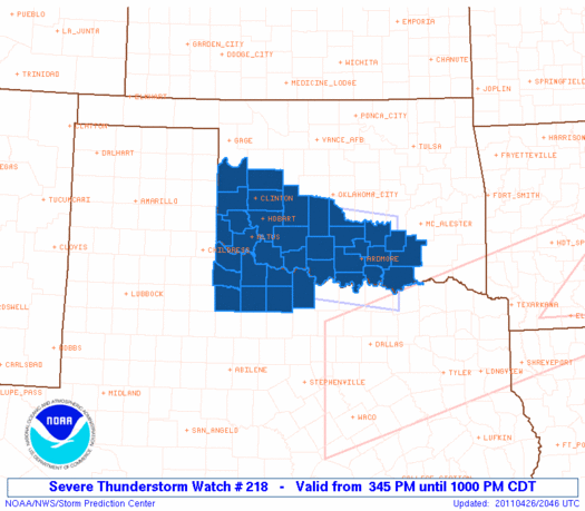
Initial List of Counties in SPC Severe Thunderstorm Watch 218 (WOU)
|
Back to Watch 218
|
 |
   WOUS64 KWNS 262040
   WOU8

   BULLETIN - IMMEDIATE BROADCAST REQUESTED
   SEVERE THUNDERSTORM WATCH OUTLINE UPDATE FOR WS 218
   NWS STORM PREDICTION CENTER NORMAN OK
   345 PM CDT TUE APR 26 2011

   SEVERE THUNDERSTORM WATCH 218 IS IN EFFECT UNTIL 1000 PM CDT
   FOR THE FOLLOWING LOCATIONS

   OKC005-009-013-015-019-029-031-033-039-049-051-055-057-065-067-
   069-075-085-087-095-099-123-129-137-141-149-270300-
   /O.NEW.KWNS.SV.A.0218.110426T2045Z-110427T0300Z/

   OK
   .    OKLAHOMA COUNTIES INCLUDED ARE

   ATOKA                BECKHAM             BRYAN
   CADDO                CARTER              COAL
   COMANCHE             COTTON              CUSTER
   GARVIN               GRADY               GREER
   HARMON               JACKSON             JEFFERSON
   JOHNSTON             KIOWA               LOVE
   MARSHALL             MCCLAIN             MURRAY
   PONTOTOC             ROGER MILLS         STEPHENS
   TILLMAN              WASHITA


   TXC009-023-077-155-197-275-485-487-270300-
   /O.NEW.KWNS.SV.A.0218.110426T2045Z-110427T0300Z/

   TX
   .    TEXAS COUNTIES INCLUDED ARE

   ARCHER               BAYLOR              CLAY
   FOARD                HARDEMAN            KNOX
   WICHITA              WILBARGER


   ATTN...WFO...OUN...
|
| Aviation Watch (SAW) for WW218 |
|---|
 |
| Note:
The Aviation Watch (SAW) product is an approximation to the watch area.
The actual watch is depicted by the shaded areas. |
   SAW8
   WW 218 SEVERE TSTM OK TX 262045Z - 270300Z
   AXIS..55 STATUTE MILES NORTH AND SOUTH OF LINE..
   40W LTS/ALTUS OK/ - 20NNE DUA/DURANT OK/
   ..AVIATION COORDS.. 50NM N/S /23NE CDS - 45E ADM/
   HAIL SURFACE AND ALOFT..2 INCHES. WIND GUSTS..60 KNOTS.
   MAX TOPS TO 450. MEAN STORM MOTION VECTOR 27035.

   LAT...LON 35439997 35009626 33419626 33849997

   THIS IS AN APPROXIMATION TO THE WATCH AREA.  FOR A
   COMPLETE DEPICTION OF THE WATCH SEE WOUS64 KWNS
   FOR WOU8.
|
|


 @NWSSPC
