|
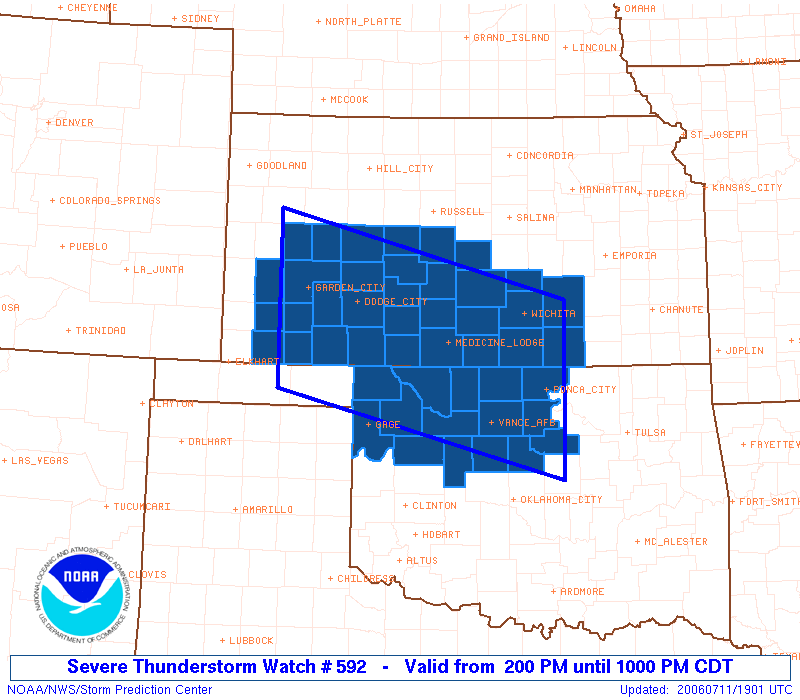
Initial List of Counties in SPC Severe Thunderstorm Watch 592 (WOU)
|
Back to Watch 592
|
 |
   WOUS64 KWNS 111855
   WOU2

   BULLETIN - IMMEDIATE BROADCAST REQUESTED
   SEVERE THUNDERSTORM WATCH OUTLINE UPDATE FOR WS 592
   NWS STORM PREDICTION CENTER NORMAN OK
   200 PM CDT TUE JUL 11 2006

   SEVERE THUNDERSTORM WATCH 592 IS IN EFFECT UNTIL 1000 PM CDT
   FOR THE FOLLOWING LOCATIONS

   KSC007-009-015-025-033-035-047-055-057-067-069-077-079-081-083-
   093-095-097-101-119-135-145-151-155-159-165-171-173-175-185-189-
   191-120300-
   /O.NEW.KWNS.SV.A.0592.060711T1900Z-060712T0300Z/

   KS
   .    KANSAS COUNTIES INCLUDED ARE

   BARBER               BARTON              BUTLER
   CLARK                COMANCHE            COWLEY
   EDWARDS              FINNEY              FORD
   GRANT                GRAY                HARPER
   HARVEY               HASKELL             HODGEMAN
   KEARNY               KINGMAN             KIOWA
   LANE                 MEADE               NESS
   PAWNEE               PRATT               RENO
   RICE                 RUSH                SCOTT
   SEDGWICK             SEWARD              STAFFORD
   STEVENS              SUMNER


   OKC003-011-043-045-047-053-059-071-073-083-093-103-119-151-153-
   120300-
   /O.NEW.KWNS.SV.A.0592.060711T1900Z-060712T0300Z/

   OK
   .    OKLAHOMA COUNTIES INCLUDED ARE

   ALFALFA              BLAINE              DEWEY
   ELLIS                GARFIELD            GRANT
   HARPER               KAY                 KINGFISHER
   LOGAN                MAJOR               NOBLE
   PAYNE                WOODS               WOODWARD


   ATTN...WFO...DDC...OUN...ICT...
|
| Aviation Watch (SAW) for WW592 |
|---|
Note:
The Aviation Watch (SAW) product is an approximation to the watch area.
The actual watch is defined by the list of counties (WOU) above.
|
   SAW2
   WW 592 SEVERE TSTM KS OK 111900Z - 120300Z
   AXIS..75 STATUTE MILES NORTH AND SOUTH OF LINE..
   15E PNC/PONCA CITY OK/ - 25WSW GCK/GARDEN CITY KS/
   ..AVIATION COORDS.. 65NM N/S /57ENE END - 21WSW GCK/
   HAIL SURFACE AND ALOFT..1.5 INCHES. WIND GUSTS..60 KNOTS.
   MAX TOPS TO 550. MEAN STORM MOTION VECTOR 31020.

   LAT...LON 35639683 36700113 38880113 37819683

   THIS IS AN APPROXIMATION TO THE WATCH AREA.  FOR A
   COMPLETE DEPICTION OF THE WATCH SEE WOUS64 KWNS
   FOR WOU2.
|
|


 @NWSSPC