|
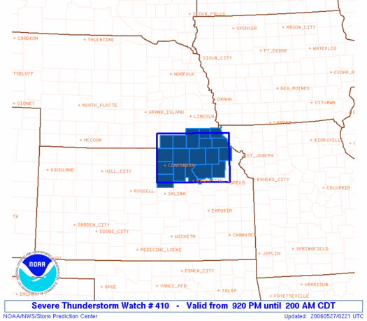
Initial List of Counties in SPC Severe Thunderstorm Watch 410 (WOU)
|
Back to Watch 410
|
 |
   WOUS64 KWNS 270216
   WOU0

   BULLETIN - IMMEDIATE BROADCAST REQUESTED
   SEVERE THUNDERSTORM WATCH OUTLINE UPDATE FOR WS 410
   NWS STORM PREDICTION CENTER NORMAN OK
   920 PM CDT FRI MAY 26 2006

   SEVERE THUNDERSTORM WATCH 410 IS IN EFFECT UNTIL 200 AM CDT
   FOR THE FOLLOWING LOCATIONS

   KSC013-027-029-085-117-131-143-149-157-161-201-270700-
   /O.NEW.KWNS.SV.A.0410.060527T0220Z-060527T0700Z/

   KS
   .    KANSAS COUNTIES INCLUDED ARE

   BROWN                CLAY                CLOUD
   JACKSON              MARSHALL            NEMAHA
   OTTAWA               POTTAWATOMIE        REPUBLIC
   RILEY                WASHINGTON


   NEC067-095-097-127-133-147-169-270700-
   /O.NEW.KWNS.SV.A.0410.060527T0220Z-060527T0700Z/

   NE
   .    NEBRASKA COUNTIES INCLUDED ARE

   GAGE                 JEFFERSON           JOHNSON
   NEMAHA               PAWNEE              RICHARDSON
   THAYER


   ATTN...WFO...TOP...GID...OAX...
|
| Aviation Watch (SAW) for WW410 |
|---|
Note:
The Aviation Watch (SAW) product is an approximation to the watch area.
The actual watch is defined by the list of counties (WOU) above.
|
   SAW0
   WW 410 SEVERE TSTM KS NE 270220Z - 270700Z
   AXIS..45 STATUTE MILES NORTH AND SOUTH OF LINE..
   20NW CNK/CONCORDIA KS/ - 25SSE FNB/FALLS CITY NE/
   ..AVIATION COORDS.. 40NM N/S /51NNW SLN - 46SE PWE/
   HAIL SURFACE AND ALOFT..2 INCHES. WIND GUSTS..60 KNOTS.
   MAX TOPS TO 500. MEAN STORM MOTION VECTOR 26035.

   LAT...LON 40409791 40389541 39089541 39099791

   THIS IS AN APPROXIMATION TO THE WATCH AREA.  FOR A
   COMPLETE DEPICTION OF THE WATCH SEE WOUS64 KWNS
   FOR WOU0.
|
|


 @NWSSPC