|
Initial List of Counties in SPC Severe Thunderstorm Watch 396 (WOU)
|
Back to Watch 396
|
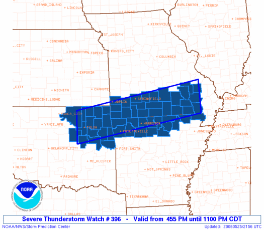 |
   WOUS64 KWNS 252151
   WOU6

   BULLETIN - IMMEDIATE BROADCAST REQUESTED
   SEVERE THUNDERSTORM WATCH OUTLINE UPDATE FOR WS 396
   NWS STORM PREDICTION CENTER NORMAN OK
   455 PM CDT THU MAY 25 2006

   SEVERE THUNDERSTORM WATCH 396 IS IN EFFECT UNTIL 1100 PM CDT
   FOR THE FOLLOWING LOCATIONS

   ARC005-007-009-015-021-049-065-087-089-101-121-129-135-137-143-
   260400-
   /O.NEW.KWNS.SV.A.0396.060525T2155Z-060526T0400Z/

   AR
   .    ARKANSAS COUNTIES INCLUDED ARE

   BAXTER               BENTON              BOONE
   CARROLL              CLAY                FULTON
   IZARD                MADISON             MARION
   NEWTON               RANDOLPH            SEARCY
   SHARP                STONE               WASHINGTON


   MOC009-023-035-043-067-077-091-093-097-109-119-123-145-149-153-
   179-181-203-209-213-215-223-225-229-260400-
   /O.NEW.KWNS.SV.A.0396.060525T2155Z-060526T0400Z/

   MO
   .    MISSOURI COUNTIES INCLUDED ARE

   BARRY                BUTLER              CARTER
   CHRISTIAN            DOUGLAS             GREENE
   HOWELL               IRON                JASPER
   LAWRENCE             MADISON             MCDONALD
   NEWTON               OREGON              OZARK
   REYNOLDS             RIPLEY              SHANNON
   STONE                TANEY               TEXAS
   WAYNE                WEBSTER             WRIGHT


   OKC001-021-035-037-041-097-101-105-111-113-115-131-135-143-145-
   147-260400-
   /O.NEW.KWNS.SV.A.0396.060525T2155Z-060526T0400Z/

   OK
   .    OKLAHOMA COUNTIES INCLUDED ARE

   ADAIR                CHEROKEE            CRAIG
   CREEK                DELAWARE            MAYES
   MUSKOGEE             NOWATA              OKMULGEE
   OSAGE                OTTAWA              ROGERS
   SEQUOYAH             TULSA               WAGONER
   WASHINGTON


   ATTN...WFO...LZK...TSA...SGF...PAH...LSX...MEG...
|
| Aviation Watch (SAW) for WW396 |
|---|
Note:
The Aviation Watch (SAW) product is an approximation to the watch area.
The actual watch is defined by the list of counties (WOU) above.
|
   SAW6
   WW 396 SEVERE TSTM AR MO OK 252155Z - 260400Z
   AXIS..45 STATUTE MILES NORTH AND SOUTH OF LINE..
   20W TUL/TULSA OK/ - 30NNE POF/POPLAR BLUFF MO/
   ..AVIATION COORDS.. 40NM N/S /22W TUL - 30S FAM/
   HAIL SURFACE AND ALOFT..3 INCHES. WIND GUSTS..70 KNOTS.
   MAX TOPS TO 550. MEAN STORM MOTION VECTOR 26025.

   LAT...LON 36849623 37819026 36529026 35549623

   THIS IS AN APPROXIMATION TO THE WATCH AREA.  FOR A
   COMPLETE DEPICTION OF THE WATCH SEE WOUS64 KWNS
   FOR WOU6.
|
|


 @NWSSPC