|
Initial List of Counties in SPC Severe Thunderstorm Watch 211 (WOU)
|
Back to Watch 211
|
 |
WOUS64 KWNS 192040
WOU1
BULLETIN - IMMEDIATE BROADCAST REQUESTED
SEVERE THUNDERSTORM WATCH OUTLINE UPDATE FOR WS 211
NWS STORM PREDICTION CENTER NORMAN OK
345 PM CDT WED APR 19 2006
SEVERE THUNDERSTORM WATCH 211 IS IN EFFECT UNTIL 1100 PM CDT
FOR THE FOLLOWING LOCATIONS
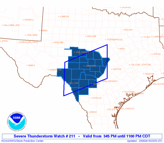
TXC019-031-053-095-137-171-259-265-267-271-299-307-319-323-325-
327-385-411-413-435-451-463-465-507-200400-
/O.NEW.KWNS.SV.A.0211.060419T2045Z-060420T0400Z/
TX
. TEXAS COUNTIES INCLUDED ARE
BANDERA BLANCO BURNET
CONCHO EDWARDS GILLESPIE
KENDALL KERR KIMBLE
KINNEY LLANO MASON
MAVERICK MCCULLOCH MEDINA
MENARD REAL SAN SABA
SCHLEICHER SUTTON TOM GREEN
UVALDE VAL VERDE ZAVALA
ATTN...WFO...EWX...SJT...
|
| Aviation Watch (SAW) for WW211 |
|---|
Note:
The Aviation Watch (SAW) product is an approximation to the watch area.
The actual watch is defined by the list of counties (WOU) above.
|
   SAW1
   WW 211 SEVERE TSTM TX 192045Z - 200400Z
   AXIS..75 STATUTE MILES NORTH AND SOUTH OF LINE..
   25NW DRT/DEL RIO TX/ - 75N BAZ/NEW BRAUNFELS TX/
   ..AVIATION COORDS.. 65NM N/S /28NW DLF - 35NNW AUS/
   HAIL SURFACE AND ALOFT..4 INCHES. WIND GUSTS..60 KNOTS.
   MAX TOPS TO 500. MEAN STORM MOTION VECTOR 29015.

   LAT...LON 30700120 31889802 29719802 28540120

   THIS IS AN APPROXIMATION TO THE WATCH AREA.  FOR A
   COMPLETE DEPICTION OF THE WATCH SEE WOUS64 KWNS
   FOR WOU1.
|
|


 @NWSSPC