|
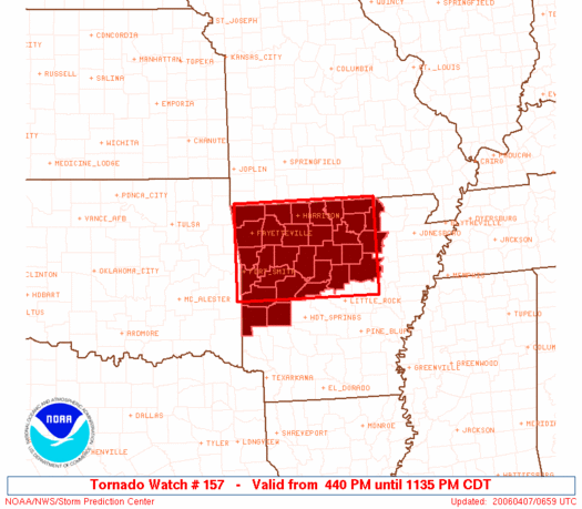
Initial List of Counties in SPC PDS Tornado Watch 157 (WOU)
|
Back to Watch 157
|
 |
   WOUS64 KWNS 062136
   WOU7

   BULLETIN - IMMEDIATE BROADCAST REQUESTED
   TORNADO WATCH OUTLINE UPDATE FOR WT 157
   NWS STORM PREDICTION CENTER NORMAN OK
   440 PM CDT THU APR 6 2006

   TORNADO WATCH 157 IS IN EFFECT UNTIL 1200 AM CDT FOR THE
    FOLLOWING LOCATIONS

   ARC005-007-009-015-023-029-033-045-047-049-063-065-071-083-087-
   089-097-101-105-113-115-127-129-131-135-137-141-143-145-149-
   070500-
   /O.NEW.KWNS.TO.A.0157.060406T2140Z-060407T0500Z/

   AR
   .    ARKANSAS COUNTIES INCLUDED ARE

   BAXTER               BENTON              BOONE
   CARROLL              CLEBURNE            CONWAY
   CRAWFORD             FAULKNER            FRANKLIN
   FULTON               INDEPENDENCE        IZARD
   JOHNSON              LOGAN               MADISON
   MARION               MONTGOMERY          NEWTON
   PERRY                POLK                POPE
   SCOTT                SEARCY              SEBASTIAN
   SHARP                STONE               VAN BUREN
   WASHINGTON           WHITE               YELL


   ATTN...WFO...LZK...TSA...
|
| Aviation Watch (SAW) for WW157 |
|---|
Note:
The Aviation Watch (SAW) product is an approximation to the watch area.
The actual watch is defined by the list of counties (WOU) above.
|
   SAW7
   WW 157 TORNADO AR 062140Z - 070500Z
   AXIS..60 STATUTE MILES NORTH AND SOUTH OF LINE..
   25NNW FSM/FORT SMITH AR/ - 10ESE BVX/BATESVILLE AR/
   ..AVIATION COORDS.. 50NM N/S /22NW FSM - 37SW ARG/
   HAIL SURFACE AND ALOFT..2 INCHES. WIND GUSTS..60 KNOTS.
   MAX TOPS TO 500. MEAN STORM MOTION VECTOR 22045.

   REPLACES WW 153..AR MO

   LAT...LON 36529454 36549148 34819148 34799454

   THIS IS AN APPROXIMATION TO THE WATCH AREA.  FOR A
   COMPLETE DEPICTION OF THE WATCH SEE WOUS64 KWNS
   FOR WOU7.
|
|


 @NWSSPC