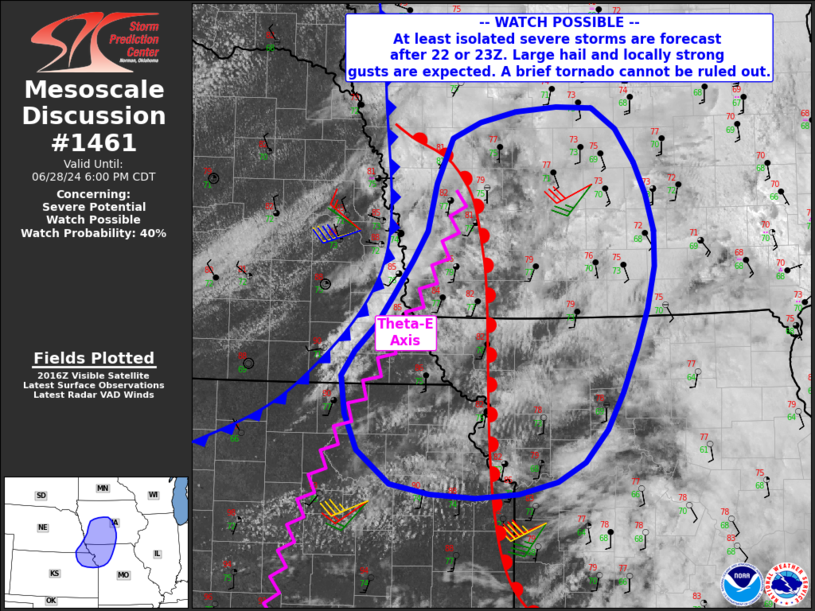
   Mesoscale Discussion 1461
   NWS Storm Prediction Center Norman OK
   0323 PM CDT Fri Jun 28 2024

   Areas affected...northeast Kansas...northwest Missouri...far
   southeast Nebraska into central Iowa

   Concerning...Severe potential...Watch possible

   Valid 282023Z - 282300Z

   Probability of Watch Issuance...40 percent

   SUMMARY...At least isolated severe storms producing large hail and
   locally damaging gusts are expected after 22/23Z, from northeast
   Kansas into central Iowa. A tornado cannot be ruled out.

   DISCUSSION...Surface observations indicate warming continuing ahead
   of a cold front which extends from near the NE/IA border into
   central KS. Meanwhile, a diffuse warm front extends from western IA
   southward along the KS/MO border, with substantial cloud cover
   limiting heating over much of IA and MO.

   Recently, clouds have thinned into southwest IA, northwest MO and
   northeast KS, with a plume of steep lapse rates developing from the
   southwest. As temperatures have risen into the mid 90s F near the KS
   portion of the front, CIN has been reduced to negligible
   proportions. However, lift is currently weak.

   Farther north into northwest MO and IA, temperatures do continue to
   slowly warm, with ample boundary layer moisture present. Eventually,
   lift along the front should interact with the increasingly uncapped
   air mass and allow for a few strong to severe storms to develop.

   Deep-layer shear of 35-40 kt along with modest low-level SRH within
   the warm advection zone may support supercells, with large hail the
   most likely severe mode. However, 0-1 km SRH over 100 m2/s2 may be
   sufficient to support a brief tornado threat in a cell or two,
   although the capping inversion and overall lack of strong upper
   support suggests this threat should remain isolated.

   ..Jewell.. 06/28/2024

   ...Please see www.spc.noaa.gov for graphic product...

   ATTN...WFO...DMX...EAX...OAX...TOP...

   LAT...LON   39609355 39159411 39019503 39139600 39439636 40069654
               40519615 41319559 41739548 42119531 42359459 42379371
               42209344 41909323 41329302 40649310 39609355
|


 @NWSSPC