|
| Mesoscale Discussion 1326 |
|
< Previous MD Next MD >
|
|
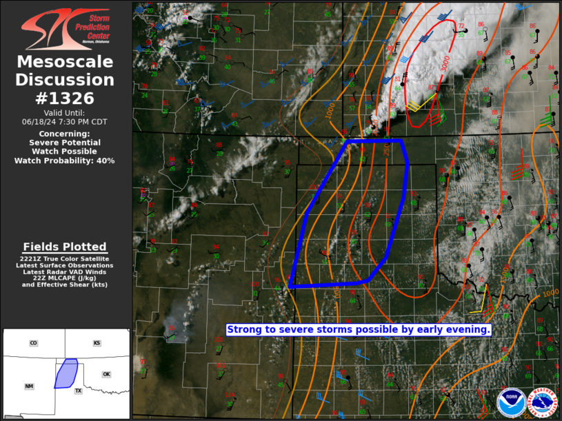
   Mesoscale Discussion 1326
   NWS Storm Prediction Center Norman OK
   0525 PM CDT Tue Jun 18 2024

   Areas affected...Parts of the OK/TX Panhandles

   Concerning...Severe potential...Watch possible

   Valid 182225Z - 190030Z

   Probability of Watch Issuance...40 percent

   SUMMARY...Strong to severe storms are possible by early evening.

   DISCUSSION...Convection continues to backbuild late this afternoon
   along a cold front across southwest KS, with increasing cumulus
   noted into parts of the central OK Panhandle. With time, deep
   convection could develop into the OK and northern TX Panhandles,
   within a very warm, well-mixed, and moderate to strongly unstable
   environment. Deep-layer shear is rather marginal across the region
   (generally 20-30 kt), but a few stronger multicells and perhaps a
   marginal supercell could develop with time, with a threat of hail
   and severe gusts. A brief landspout will also be possible near the
   front/dryline intersection across the central OK Panhandle.

   Farther south, uncertainty increases regarding the coverage of storm
   development into early evening across parts of the central/southern
   TX Panhandle. However, a subtle southern-stream shortwave trough
   could aid in development of a couple stronger storms capable of hail
   and isolated severe gusts.

   Watch issuance is possible if observational trends begin to support
   the potential for multiple severe storms across the region into this
   evening.

   ..Dean/Edwards.. 06/18/2024

   ...Please see www.spc.noaa.gov for graphic product...

   ATTN...WFO...LUB...AMA...ABQ...

   LAT...LON   35650281 36910194 36920076 36530062 35910072 34850110
               34460149 34410174 34330315 35650281
|
|
Top/All Mesoscale Discussions/Forecast Products/Home
|
|


 @NWSSPC