|
| Mesoscale Discussion 1313 |
|
< Previous MD Next MD >
|
|
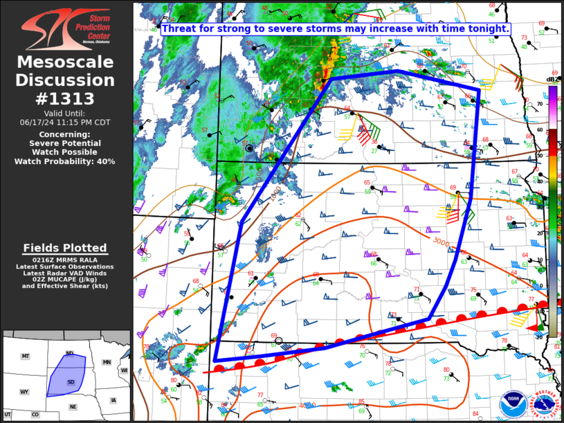
   Mesoscale Discussion 1313
   NWS Storm Prediction Center Norman OK
   0919 PM CDT Mon Jun 17 2024

   Areas affected...Northern NE Panhandle into western/central SD and
   southern/central ND

   Concerning...Severe potential...Watch possible

   Valid 180219Z - 180415Z

   Probability of Watch Issuance...40 percent

   SUMMARY...The threat for strong to severe storms may increase with
   time tonight.

   DISCUSSION...A warm front is draped across northern NE into
   southeast SD this evening, with some elevated convection gradually
   increasing over southwest SD into extreme eastern WY, and also much
   farther north into western ND. An approaching mid/upper-level
   shortwave trough and strong southerly low-level jet will support an
   increase in elevated convection north of the front with time
   tonight. Very steep midlevel lapse rates (as noted on the 00Z LBF
   and UNR soundings), moderate to strong elevated buoyancy, and
   effective shear of 50+ kt will support organized convection. There
   will be some potential for elevated supercells with an attendant
   hail threat, though a tendency toward more of a cluster or linear
   mode with time could temper hail potential to some extent. Localized
   strong/severe gusts will also be possible, especially if organized
   upscale growth occurs. Watch issuance is possible over parts of the
   area later this evening in response to these threats.

   ..Dean/Edwards.. 06/18/2024

   ...Please see www.spc.noaa.gov for graphic product...

   ATTN...WFO...FGF...FSD...ABR...BIS...LBF...UNR...CYS...

   LAT...LON   44960341 47320138 47449978 47119785 45349813 44359851
               43929874 43399915 43110053 42920148 42760291 42660393
               44960341
|
|
Top/All Mesoscale Discussions/Forecast Products/Home
|
|


 @NWSSPC