|
| Mesoscale Discussion 1306 |
|
< Previous MD
|
|
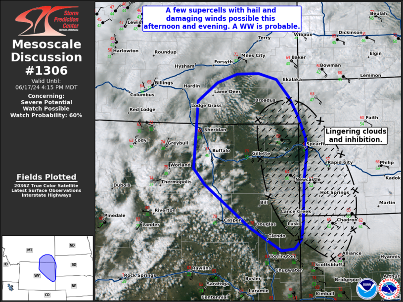
   Mesoscale Discussion 1306
   NWS Storm Prediction Center Norman OK
   0345 PM CDT Mon Jun 17 2024

   Areas affected...portions of eastern Wyoming...southeastern Montana
   and far western South Dakota

   Concerning...Severe potential...Watch possible

   Valid 172045Z - 172215Z

   Probability of Watch Issuance...60 percent

   SUMMARY...Thunderstorms are expected to develop off the Bighorns and
   higher terrain later this afternoon. A few supercells may evolve
   with a risk for large hail and damaging winds. There remains some
   uncertainty on the southern and eastern extent of the severe risk,
   but a WW is being considered.

   DISCUSSION...Across portions of central and northeastern WY,
   afternoon visible imagery showed increasing vertical development of
   cumulus near the Bighorn Mountains and higher terrain. Over the last
   several hours, diurnal heating and upslope flow have increased ahead
   of an approaching upper trough and a deepening surface low over
   south-central WY. As forcing for ascent increases, remaining
   inhibition will quickly be removed supporting thunderstorm
   development this afternoon. Confidence in convective development
   remains highest across north-central WY near the Bighorns where
   low-level upslope flow is maximized beneath the coldest mid-level
   temperatures. However, strong low-level mass response is occurring
   ahead of the deepening surface low over southeastern WY which could
   support an isolated storm or two farther south.

   While low-level moisture is not overly deep or rich, low 50s F
   surface dewpoints have surged westward into eastern WY and portions
   of southern MT. With 500-1000 J/kg of MLCAPE in place, a few
   stronger updrafts are likely to evolve as the initial convection
   moves off of the higher terrain. There remains some uncertainty on
   the eastward extent of destabilization given lingering cloud cover,
   though clearing is ongoing. Strong flow aloft ahead of the upper
   trough is supporting robust vertical shear profiles with relatively
   long hodographs and 50+ kt of effective shear. More than sufficient
   to support organized rotating updrafts, these storms will likely be
   capable of large hail and damaging gusts. A brief tornado can also
   not be ruled out given some low-level veering and potential for
   terrain enhanced low-level shear. Given the potential for a few
   supercells capable of hail and damaging winds, a new WW may be
   needed in the next 1-2 hours.

   ..Lyons/Halbert/Gleason.. 06/17/2024

   ...Please see www.spc.noaa.gov for graphic product...

   ATTN...WFO...UNR...CYS...BYZ...RIW...

   LAT...LON   42870395 42480400 42290421 42250460 42740553 43680688
               44030721 45480711 45890652 46080591 46080526 45960471
               45570434 45160407 44710385 44360382 43780390 42870395
|
|
Top/All Mesoscale Discussions/Forecast Products/Home
|
|


 @NWSSPC